You are here: Home > Network List > GE - GEOFON Stations List
> Station APE GEOFON/NOA Station Apirathos, Naxos, Greece > Earthquake Result Viewer
APE GEOFON/NOA Station Apirathos, Naxos, Greece - Earthquake Result Viewer
| Earthquake location: |
Lake Tanganyika Region |
| Earthquake latitude/longitude: |
-1.9/29.0 |
| Earthquake time(UTC): |
2002/10/24 (297) 06:08:37 GMT |
| Earthquake Depth: |
11 km |
| Earthquake Magnitude: |
5.9 MB, 6.3 MS, 6.2 MW, 6.1 MW |
| Earthquake Catalog/Contributor: |
WHDF/NEIC |
|
| Network: |
GE GEOFON |
| Station: |
APE GEOFON/NOA Station Apirathos, Naxos, Greece |
| Lat/Lon: |
37.07 N/25.53 E |
| Elevation: |
620 m |
|
| Distance: |
38.9 deg |
| Az: |
355.573 deg |
| Baz: |
174.465 deg |
| Ray Param: |
0.075298496 |
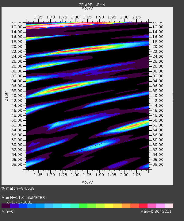
| Estimated Moho Depth: |
11.0 km |
| Estimated Crust Vp/Vs: |
1.74 |
| Assumed Crust Vp: |
5.738 km/s |
| Estimated Crust Vs: |
3.303 km/s |
| Estimated Crust Poisson's Ratio: |
0.25 |
|
| Radial Match: |
84.538 % |
| Radial Bump: |
392 |
| Transverse Match: |
75.586075 % |
| Transverse Bump: |
400 |
| SOD ConfigId: |
4714 |
| Insert Time: |
2010-03-09 06:39:51.046 +0000 |
| GWidth: |
2.5 |
| Max Bumps: |
400 |
| Tol: |
0.001 |
|

Signal To Noise
| Channel | StoN | STA | LTA |
| GE:APE: :BHN:20021024T06:15:32.57201Z | 7.6743293 | 7.116077E-7 | 9.272572E-8 |
| GE:APE: :BHE:20021024T06:15:32.57201Z | 1.5394648 | 1.297058E-7 | 8.425382E-8 |
| GE:APE: :BHZ:20021024T06:15:32.57201Z | 8.728579 | 1.0776107E-6 | 1.2345775E-7 |
| Arrivals |
| Ps | 1.5 SECOND |
| PpPs | 5.0 SECOND |
| PsPs/PpSs | 6.5 SECOND |


