You are here: Home > Network List > GE - GEOFON Stations List
> Station APE GEOFON/NOA Station Apirathos, Naxos, Greece > Earthquake Result Viewer
APE GEOFON/NOA Station Apirathos, Naxos, Greece - Earthquake Result Viewer
| Earthquake location: |
Lake Tanganyika Region |
| Earthquake latitude/longitude: |
-6.2/29.8 |
| Earthquake time(UTC): |
2005/12/05 (339) 12:19:56 GMT |
| Earthquake Depth: |
22 km |
| Earthquake Magnitude: |
6.4 MB, 7.2 MS, 6.8 MW, 6.7 MW |
| Earthquake Catalog/Contributor: |
WHDF/NEIC |
|
| Network: |
GE GEOFON |
| Station: |
APE GEOFON/NOA Station Apirathos, Naxos, Greece |
| Lat/Lon: |
37.07 N/25.53 E |
| Elevation: |
620 m |
|
| Distance: |
43.3 deg |
| Az: |
354.98 deg |
| Baz: |
173.756 deg |
| Ray Param: |
0.07263749 |
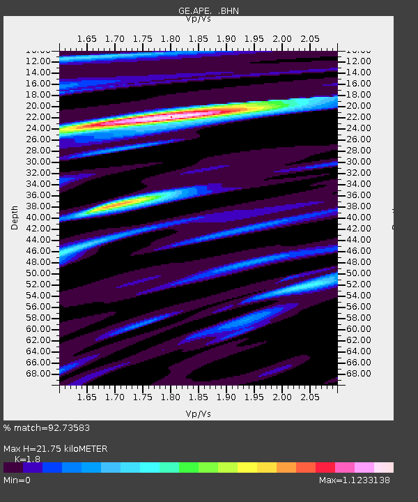
| Estimated Moho Depth: |
21.75 km |
| Estimated Crust Vp/Vs: |
1.80 |
| Assumed Crust Vp: |
5.738 km/s |
| Estimated Crust Vs: |
3.188 km/s |
| Estimated Crust Poisson's Ratio: |
0.28 |
|
| Radial Match: |
92.73583 % |
| Radial Bump: |
339 |
| Transverse Match: |
84.79891 % |
| Transverse Bump: |
400 |
| SOD ConfigId: |
2422 |
| Insert Time: |
2010-03-09 06:40:13.488 +0000 |
| GWidth: |
2.5 |
| Max Bumps: |
400 |
| Tol: |
0.001 |
|

Signal To Noise
| Channel | StoN | STA | LTA |
| GE:APE: :BHN:20051205T12:27:25.530004Z | 43.372566 | 3.0274982E-6 | 6.980215E-8 |
| GE:APE: :BHE:20051205T12:27:25.530004Z | 3.657136 | 3.2499392E-7 | 8.88657E-8 |
| GE:APE: :BHZ:20051205T12:27:25.530004Z | 47.13499 | 4.4842413E-6 | 9.5136144E-8 |
| Arrivals |
| Ps | 3.2 SECOND |
| PpPs | 10 SECOND |
| PsPs/PpSs | 13 SECOND |


