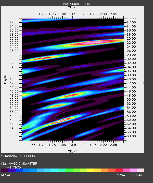
KARL XW.KARL - Earthquake Result Viewer
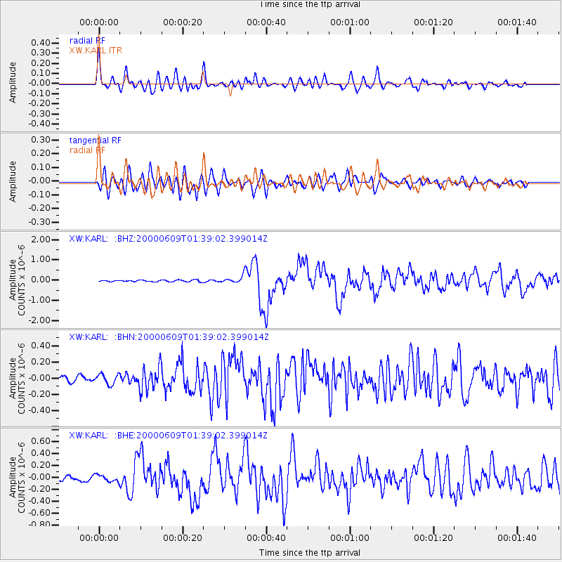
Earthquake location: New Britain Region, P.N.G.
Earthquake latitude/longitude: -5.1/152.5
Earthquake time(UTC): 2000/06/09 (161) 01:27:15 GMT
Earthquake Depth: 33 km
Earthquake Magnitude: 5.4 MB, 6.3 MS, 6.3 MW, 6.3 MW
Earthquake Catalog/Contributor: WHDF/NEIC
Network: XW Tien Shan Continental Dynamics
Station: KARL XW.KARL
Lat/Lon: 41.47 N/77.31 E
Elevation: 3021 m
Distance: 82.3 deg
Az: 312.858 deg
Baz: 103.659 deg
Ray Param: 0.04691828
Estimated Moho Depth: 60.0 km
Estimated Crust Vp/Vs: 1.80
Assumed Crust Vp: 6.491 km/s
Estimated Crust Vs: 3.611 km/s
Estimated Crust Poisson's Ratio: 0.28
Radial Match: 86.803085 %
Radial Bump: 400
Transverse Match: 83.03949 %
Transverse Bump: 400
SOD ConfigId: 20082
Insert Time: 2010-02-26 15:26:50.821 +0000
GWidth: 2.5
Max Bumps: 400
Tol: 0.001

Signal To Noise

ChannelStoNSTALTA
XW:KARL: :BHN:20000609T01:39:02.399014Z1.40728766.4053864E-84.551583E-8
XW:KARL: :BHE:20000609T01:39:02.399014Z1.66856155.5568265E-83.33031E-8
XW:KARL: :BHZ:20000609T01:39:02.399014Z4.38350341.8062933E-74.120661E-8
Arrivals
Ps7.6 SECOND
PpPs25 SECOND
PsPs/PpSs33 SECOND