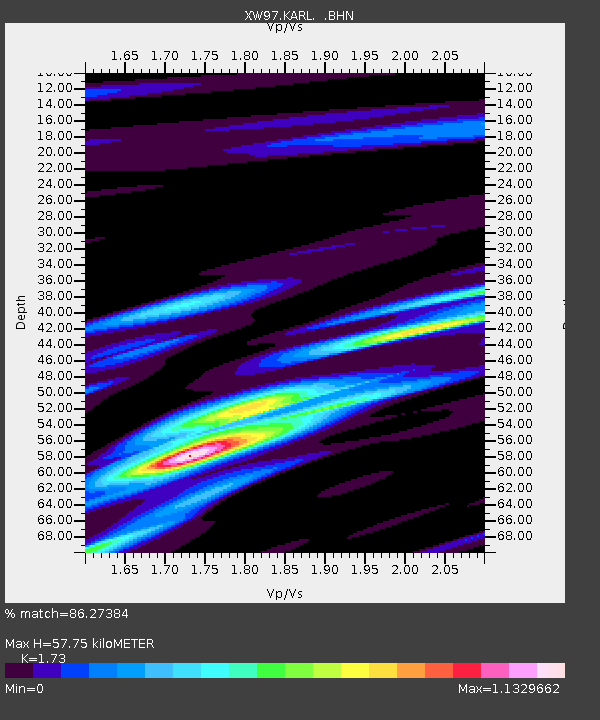
KARL XW.KARL - Earthquake Result Viewer
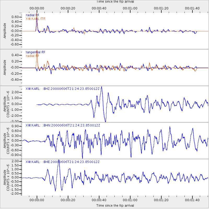
Earthquake location: Sea Of Japan
Earthquake latitude/longitude: 36.8/135.5
Earthquake time(UTC): 2000/06/06 (158) 21:16:42 GMT
Earthquake Depth: 10 km
Earthquake Magnitude: 5.7 MB, 5.3 MS, 5.9 MW, 5.8 MW
Earthquake Catalog/Contributor: WHDF/NEIC
Network: XW Tien Shan Continental Dynamics
Station: KARL XW.KARL
Lat/Lon: 41.47 N/77.31 E
Elevation: 3021 m
Distance: 44.6 deg
Az: 294.634 deg
Baz: 76.058 deg
Ray Param: 0.07181113
Estimated Moho Depth: 57.75 km
Estimated Crust Vp/Vs: 1.73
Assumed Crust Vp: 6.491 km/s
Estimated Crust Vs: 3.752 km/s
Estimated Crust Poisson's Ratio: 0.25
Radial Match: 86.27384 %
Radial Bump: 400
Transverse Match: 75.96403 %
Transverse Bump: 400
SOD ConfigId: 20082
Insert Time: 2010-02-26 15:26:53.419 +0000
GWidth: 2.5
Max Bumps: 400
Tol: 0.001

Signal To Noise

ChannelStoNSTALTA
XW:KARL: :BHN:20000606T21:24:23.850012Z0.653779152.6180759E-84.004526E-8
XW:KARL: :BHE:20000606T21:24:23.850012Z4.1685777.9136214E-81.8983988E-8
XW:KARL: :BHZ:20000606T21:24:23.850012Z3.31557851.878724E-75.6663538E-8
Arrivals
Ps7.0 SECOND
PpPs23 SECOND
PsPs/PpSs30 SECOND