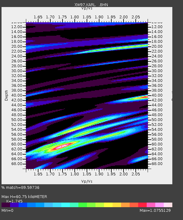
KARL XW.KARL - Earthquake Result Viewer
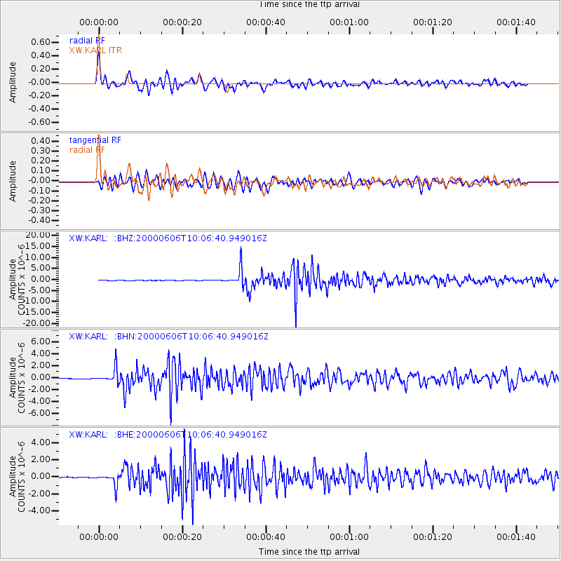
Earthquake location: Southern Sumatra, Indonesia
Earthquake latitude/longitude: -5.1/102.7
Earthquake time(UTC): 2000/06/06 (158) 09:58:06 GMT
Earthquake Depth: 33 km
Earthquake Magnitude: 5.8 MB, 6.1 MS, 6.2 MW, 6.1 MW
Earthquake Catalog/Contributor: WHDF/NEIC
Network: XW Tien Shan Continental Dynamics
Station: KARL XW.KARL
Lat/Lon: 41.47 N/77.31 E
Elevation: 3021 m
Distance: 51.8 deg
Az: 335.804 deg
Baz: 147.092 deg
Ray Param: 0.06709554
Estimated Moho Depth: 60.75 km
Estimated Crust Vp/Vs: 1.75
Assumed Crust Vp: 6.491 km/s
Estimated Crust Vs: 3.72 km/s
Estimated Crust Poisson's Ratio: 0.26
Radial Match: 89.59736 %
Radial Bump: 400
Transverse Match: 85.40635 %
Transverse Bump: 400
SOD ConfigId: 20082
Insert Time: 2010-02-26 15:26:55.398 +0000
GWidth: 2.5
Max Bumps: 400
Tol: 0.001

Signal To Noise

ChannelStoNSTALTA
XW:KARL: :BHN:20000606T10:06:40.949016Z39.086671.2555787E-63.2122937E-8
XW:KARL: :BHE:20000606T10:06:40.949016Z15.7527767.190741E-74.564745E-8
XW:KARL: :BHZ:20000606T10:06:40.949016Z80.0847553.8938174E-64.8621207E-8
Arrivals
Ps7.4 SECOND
PpPs24 SECOND
PsPs/PpSs32 SECOND