You are here: Home > Network List > XW97 - Tien Shan Continental Dynamics Stations List
> Station KARL XW.KARL > Earthquake Result Viewer
KARL XW.KARL - Earthquake Result Viewer
| Earthquake location: |
Southern Sumatra, Indonesia |
| Earthquake latitude/longitude: |
-4.9/102.7 |
| Earthquake time(UTC): |
2000/06/05 (157) 06:34:11 GMT |
| Earthquake Depth: |
33 km |
| Earthquake Magnitude: |
5.4 MB, 5.5 MS, 5.8 MW |
| Earthquake Catalog/Contributor: |
WHDF/NEIC |
|
| Network: |
XW Tien Shan Continental Dynamics |
| Station: |
KARL XW.KARL |
| Lat/Lon: |
41.47 N/77.31 E |
| Elevation: |
3021 m |
|
| Distance: |
51.6 deg |
| Az: |
335.779 deg |
| Baz: |
147.046 deg |
| Ray Param: |
0.06721793 |
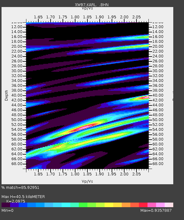
| Estimated Moho Depth: |
40.5 km |
| Estimated Crust Vp/Vs: |
2.10 |
| Assumed Crust Vp: |
6.491 km/s |
| Estimated Crust Vs: |
3.095 km/s |
| Estimated Crust Poisson's Ratio: |
0.35 |
|
| Radial Match: |
85.92951 % |
| Radial Bump: |
400 |
| Transverse Match: |
82.068565 % |
| Transverse Bump: |
400 |
| SOD ConfigId: |
20082 |
| Insert Time: |
2010-02-26 15:26:57.228 +0000 |
| GWidth: |
2.5 |
| Max Bumps: |
400 |
| Tol: |
0.001 |
|
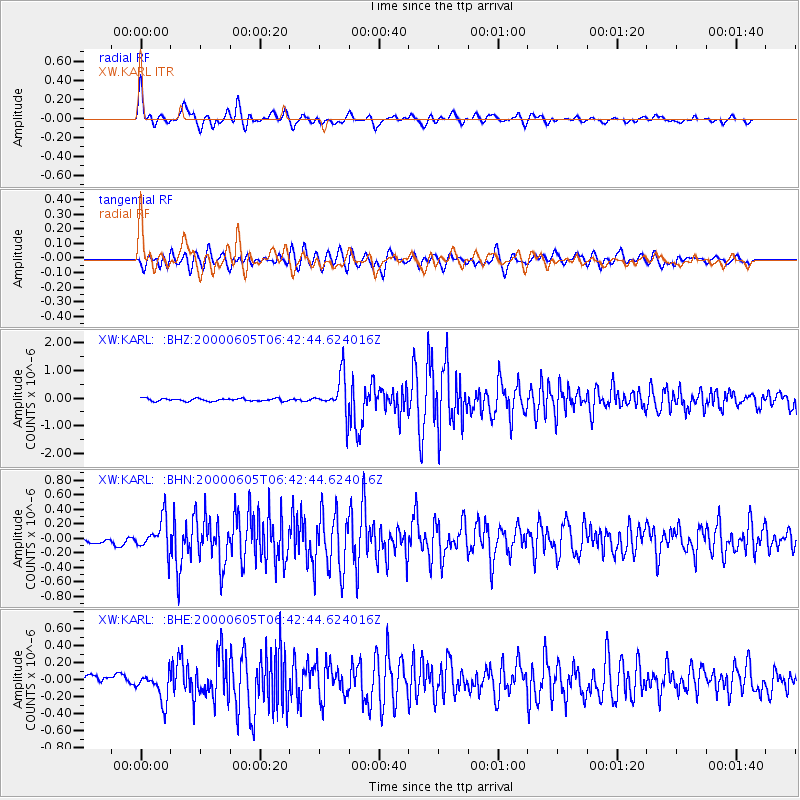
Signal To Noise
| Channel | StoN | STA | LTA |
| XW:KARL: :BHN:20000605T06:42:44.624016Z | 7.5861464 | 2.2439079E-7 | 2.9579022E-8 |
| XW:KARL: :BHE:20000605T06:42:44.624016Z | 3.8363137 | 1.7035703E-7 | 4.440644E-8 |
| XW:KARL: :BHZ:20000605T06:42:44.624016Z | 14.374049 | 6.801076E-7 | 4.731496E-8 |
| Arrivals |
| Ps | 7.2 SECOND |
| PpPs | 18 SECOND |
| PsPs/PpSs | 26 SECOND |


