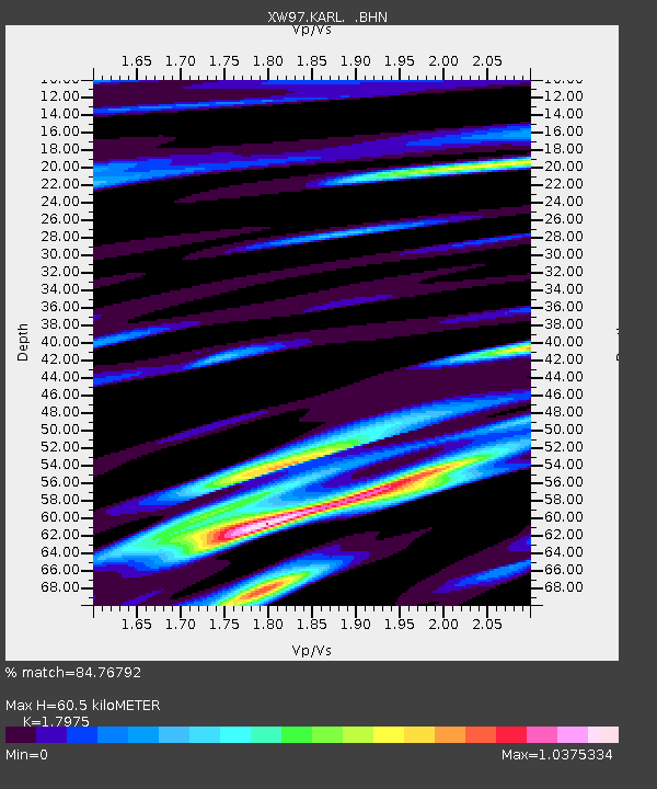
KARL XW.KARL - Earthquake Result Viewer
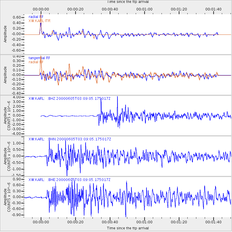
Earthquake location: Southern Sumatra, Indonesia
Earthquake latitude/longitude: -5.6/102.9
Earthquake time(UTC): 2000/06/05 (157) 03:00:26 GMT
Earthquake Depth: 33 km
Earthquake Magnitude: 5.5 MB, 5.5 MS, 5.8 MW, 5.8 MW
Earthquake Catalog/Contributor: WHDF/NEIC
Network: XW Tien Shan Continental Dynamics
Station: KARL XW.KARL
Lat/Lon: 41.47 N/77.31 E
Elevation: 3021 m
Distance: 52.4 deg
Az: 335.816 deg
Baz: 147.141 deg
Ray Param: 0.06674506
Estimated Moho Depth: 60.5 km
Estimated Crust Vp/Vs: 1.80
Assumed Crust Vp: 6.491 km/s
Estimated Crust Vs: 3.611 km/s
Estimated Crust Poisson's Ratio: 0.28
Radial Match: 84.76792 %
Radial Bump: 400
Transverse Match: 82.435394 %
Transverse Bump: 400
SOD ConfigId: 20082
Insert Time: 2010-02-26 15:26:58.438 +0000
GWidth: 2.5
Max Bumps: 400
Tol: 0.001

Signal To Noise

ChannelStoNSTALTA
XW:KARL: :BHN:20000605T03:09:05.175017Z6.79385042.7611486E-74.0641883E-8
XW:KARL: :BHE:20000605T03:09:05.175017Z4.19577551.474547E-73.514361E-8
XW:KARL: :BHZ:20000605T03:09:05.175017Z14.0340358.339411E-75.942276E-8
Arrivals
Ps7.9 SECOND
PpPs25 SECOND
PsPs/PpSs33 SECOND