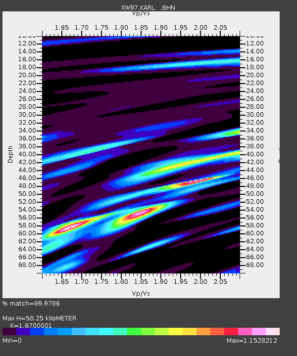
KARL XW.KARL - Earthquake Result Viewer
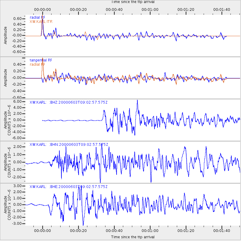
Earthquake location: Near East Coast Of Honshu, Japan
Earthquake latitude/longitude: 35.6/140.5
Earthquake time(UTC): 2000/06/03 (155) 08:54:49 GMT
Earthquake Depth: 62 km
Earthquake Magnitude: 5.6 MB, 5.6 MS, 6.1 MW, 6.1 MW
Earthquake Catalog/Contributor: WHDF/NEIC
Network: XW Tien Shan Continental Dynamics
Station: KARL XW.KARL
Lat/Lon: 41.47 N/77.31 E
Elevation: 3021 m
Distance: 48.8 deg
Az: 296.996 deg
Baz: 75.214 deg
Ray Param: 0.068933524
Estimated Moho Depth: 58.25 km
Estimated Crust Vp/Vs: 1.67
Assumed Crust Vp: 6.491 km/s
Estimated Crust Vs: 3.887 km/s
Estimated Crust Poisson's Ratio: 0.22
Radial Match: 89.9786 %
Radial Bump: 400
Transverse Match: 84.04191 %
Transverse Bump: 400
SOD ConfigId: 20082
Insert Time: 2010-02-26 15:27:01.797 +0000
GWidth: 2.5
Max Bumps: 400
Tol: 0.001

Signal To Noise

ChannelStoNSTALTA
XW:KARL: :BHN:20000603T09:02:57.575Z1.34889531.2805988E-79.493686E-8
XW:KARL: :BHE:20000603T09:02:57.575Z5.4689965.592293E-71.02254475E-7
XW:KARL: :BHZ:20000603T09:02:57.575Z15.3329011.2359932E-68.0610526E-8
Arrivals
Ps6.4 SECOND
PpPs22 SECOND
PsPs/PpSs29 SECOND