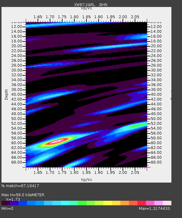
KARL XW.KARL - Earthquake Result Viewer

Earthquake location: Banda Sea
Earthquake latitude/longitude: -4.3/123.2
Earthquake time(UTC): 2000/05/14 (135) 20:08:34 GMT
Earthquake Depth: 33 km
Earthquake Magnitude: 5.9 MB, 5.9 MS, 6.3 MW, 6.2 MW
Earthquake Catalog/Contributor: WHDF/NEIC
Network: XW Tien Shan Continental Dynamics
Station: KARL XW.KARL
Lat/Lon: 41.47 N/77.31 E
Elevation: 3021 m
Distance: 61.8 deg
Az: 322.268 deg
Baz: 125.698 deg
Ray Param: 0.06060201
Estimated Moho Depth: 59.0 km
Estimated Crust Vp/Vs: 1.73
Assumed Crust Vp: 6.491 km/s
Estimated Crust Vs: 3.752 km/s
Estimated Crust Poisson's Ratio: 0.25
Radial Match: 87.18417 %
Radial Bump: 400
Transverse Match: 77.450386 %
Transverse Bump: 400
SOD ConfigId: 20082
Insert Time: 2010-02-26 15:27:05.842 +0000
GWidth: 2.5
Max Bumps: 400
Tol: 0.001

Signal To Noise

ChannelStoNSTALTA
XW:KARL: :BHN:20000514T20:18:19.000024Z3.3252011.3649104E-74.1047453E-8
XW:KARL: :BHE:20000514T20:18:19.000024Z5.89416932.3597549E-74.0035413E-8
XW:KARL: :BHZ:20000514T20:18:19.000024Z14.0082757.3896877E-75.2752302E-8
Arrivals
Ps7.0 SECOND
PpPs24 SECOND
PsPs/PpSs31 SECOND