You are here: Home > Network List > XW97 - Tien Shan Continental Dynamics Stations List
> Station KARL XW.KARL > Earthquake Result Viewer
KARL XW.KARL - Earthquake Result Viewer
| Earthquake location: |
Mariana Islands Region |
| Earthquake latitude/longitude: |
17.4/147.5 |
| Earthquake time(UTC): |
2000/05/02 (123) 15:03:36 GMT |
| Earthquake Depth: |
55 km |
| Earthquake Magnitude: |
5.8 MB, 5.9 MW, 5.9 MW |
| Earthquake Catalog/Contributor: |
WHDF/NEIC |
|
| Network: |
XW Tien Shan Continental Dynamics |
| Station: |
KARL XW.KARL |
| Lat/Lon: |
41.47 N/77.31 E |
| Elevation: |
3021 m |
|
| Distance: |
63.9 deg |
| Az: |
308.081 deg |
| Baz: |
89.327 deg |
| Ray Param: |
0.059128396 |
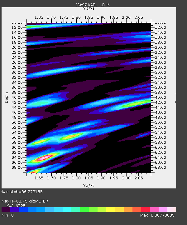
| Estimated Moho Depth: |
63.75 km |
| Estimated Crust Vp/Vs: |
1.67 |
| Assumed Crust Vp: |
6.491 km/s |
| Estimated Crust Vs: |
3.881 km/s |
| Estimated Crust Poisson's Ratio: |
0.22 |
|
| Radial Match: |
86.273155 % |
| Radial Bump: |
400 |
| Transverse Match: |
81.24198 % |
| Transverse Bump: |
400 |
| SOD ConfigId: |
20082 |
| Insert Time: |
2010-02-26 15:27:12.988 +0000 |
| GWidth: |
2.5 |
| Max Bumps: |
400 |
| Tol: |
0.001 |
|
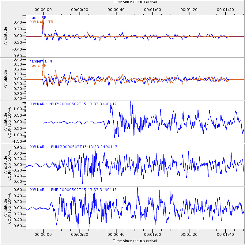
Signal To Noise
| Channel | StoN | STA | LTA |
| XW:KARL: :BHN:20000502T15:13:33.349011Z | 1.9595156 | 4.175634E-8 | 2.1309523E-8 |
| XW:KARL: :BHE:20000502T15:13:33.349011Z | 2.3906128 | 7.549559E-8 | 3.1580015E-8 |
| XW:KARL: :BHZ:20000502T15:13:33.349011Z | 3.206431 | 1.6248534E-7 | 5.0674828E-8 |
| Arrivals |
| Ps | 6.9 SECOND |
| PpPs | 25 SECOND |
| PsPs/PpSs | 32 SECOND |


