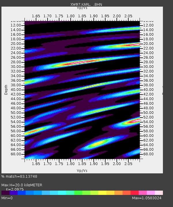
KARL XW.KARL - Earthquake Result Viewer
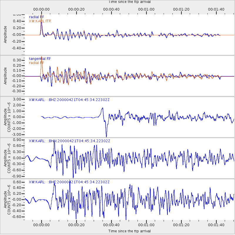
Earthquake location: Andreanof Islands, Aleutian Is.
Earthquake latitude/longitude: 51.4/-178.1
Earthquake time(UTC): 2000/04/21 (112) 04:35:17 GMT
Earthquake Depth: 33 km
Earthquake Magnitude: 6.0 MB, 5.7 MS, 6.2 ML, 6.0 MW
Earthquake Catalog/Contributor: WHDF/NEIC
Network: XW Tien Shan Continental Dynamics
Station: KARL XW.KARL
Lat/Lon: 41.47 N/77.31 E
Elevation: 3021 m
Distance: 66.7 deg
Az: 307.61 deg
Baz: 41.305 deg
Ray Param: 0.05741659
Estimated Moho Depth: 20.0 km
Estimated Crust Vp/Vs: 2.10
Assumed Crust Vp: 6.491 km/s
Estimated Crust Vs: 3.095 km/s
Estimated Crust Poisson's Ratio: 0.35
Radial Match: 83.13748 %
Radial Bump: 400
Transverse Match: 75.86263 %
Transverse Bump: 400
SOD ConfigId: 20082
Insert Time: 2010-02-26 15:27:15.328 +0000
GWidth: 2.5
Max Bumps: 400
Tol: 0.001

Signal To Noise

ChannelStoNSTALTA
XW:KARL: :BHN:20000421T04:45:34.22302Z2.05629561.2641394E-76.147654E-8
XW:KARL: :BHE:20000421T04:45:34.22302Z1.29222068.262284E-86.393865E-8
XW:KARL: :BHZ:20000421T04:45:34.22302Z7.28010755.5451375E-77.616834E-8
Arrivals
Ps3.5 SECOND
PpPs9.2 SECOND
PsPs/PpSs13 SECOND