You are here: Home > Network List > XW97 - Tien Shan Continental Dynamics Stations List
> Station KARL XW.KARL > Earthquake Result Viewer
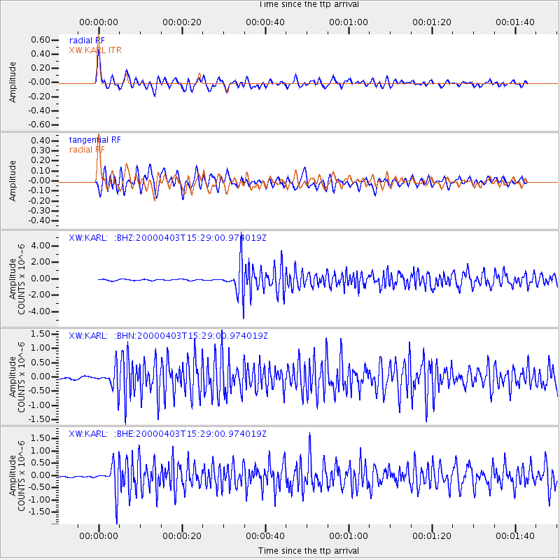
KARL XW.KARL - Earthquake Result Viewer

| Earthquake location: |
Talaud Islands, Indonesia |
| Earthquake latitude/longitude: |
4.1/125.6 |
| Earthquake time(UTC): |
2000/04/03 (094) 15:20:01 GMT |
| Earthquake Depth: |
150 km |
| Earthquake Magnitude: |
5.9 MB, 6.2 MW, 6.0 MW |
| Earthquake Catalog/Contributor: |
WHDF/NEIC |
|
| Network: |
XW Tien Shan Continental Dynamics |
| Station: |
KARL XW.KARL |
| Lat/Lon: |
41.47 N/77.31 E |
| Elevation: |
3021 m |
|
| Distance: |
57.0 deg |
| Az: |
317.983 deg |
| Baz: |
117.315 deg |
| Ray Param: |
0.063331574 |
| Estimated Moho Depth: |
61.75 km |
| Estimated Crust Vp/Vs: |
1.67 |
| Assumed Crust Vp: |
6.491 km/s |
| Estimated Crust Vs: |
3.887 km/s |
| Estimated Crust Poisson's Ratio: |
0.22 |
|
| Radial Match: |
89.39312 % |
| Radial Bump: |
400 |
| Transverse Match: |
84.26591 % |
| Transverse Bump: |
400 |
| SOD ConfigId: |
20082 |
| Insert Time: |
2010-02-26 15:27:17.242 +0000 |
| GWidth: |
2.5 |
| Max Bumps: |
400 |
| Tol: |
0.001 |
|
Signal To Noise
| Channel | StoN | STA | LTA |
| XW:KARL: :BHN:20000403T15:29:00.974019Z | 7.897407 | 3.6691281E-7 | 4.645991E-8 |
| XW:KARL: :BHE:20000403T15:29:00.974019Z | 19.600399 | 5.7941537E-7 | 2.9561408E-8 |
| XW:KARL: :BHZ:20000403T15:29:00.974019Z | 25.865189 | 1.9032249E-6 | 7.3582484E-8 |
| Arrivals |
| Ps | 6.7 SECOND |
| PpPs | 24 SECOND |
| PsPs/PpSs | 31 SECOND |


