You are here: Home > Network List > XW97 - Tien Shan Continental Dynamics Stations List
> Station KARL XW.KARL > Earthquake Result Viewer
KARL XW.KARL - Earthquake Result Viewer
| Earthquake location: |
Minahassa Peninsula, Sulawesi |
| Earthquake latitude/longitude: |
0.3/122.1 |
| Earthquake time(UTC): |
2000/04/03 (094) 08:55:00 GMT |
| Earthquake Depth: |
187 km |
| Earthquake Magnitude: |
5.6 MB, 5.5 MW, 5.4 MW |
| Earthquake Catalog/Contributor: |
WHDF/NEIC |
|
| Network: |
XW Tien Shan Continental Dynamics |
| Station: |
KARL XW.KARL |
| Lat/Lon: |
41.47 N/77.31 E |
| Elevation: |
3021 m |
|
| Distance: |
57.5 deg |
| Az: |
321.174 deg |
| Baz: |
123.457 deg |
| Ray Param: |
0.06282304 |
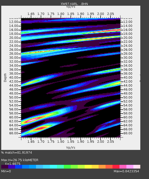
| Estimated Moho Depth: |
26.75 km |
| Estimated Crust Vp/Vs: |
1.69 |
| Assumed Crust Vp: |
6.491 km/s |
| Estimated Crust Vs: |
3.846 km/s |
| Estimated Crust Poisson's Ratio: |
0.23 |
|
| Radial Match: |
81.91974 % |
| Radial Bump: |
400 |
| Transverse Match: |
68.31699 % |
| Transverse Bump: |
400 |
| SOD ConfigId: |
20082 |
| Insert Time: |
2010-02-26 15:27:18.482 +0000 |
| GWidth: |
2.5 |
| Max Bumps: |
400 |
| Tol: |
0.001 |
|
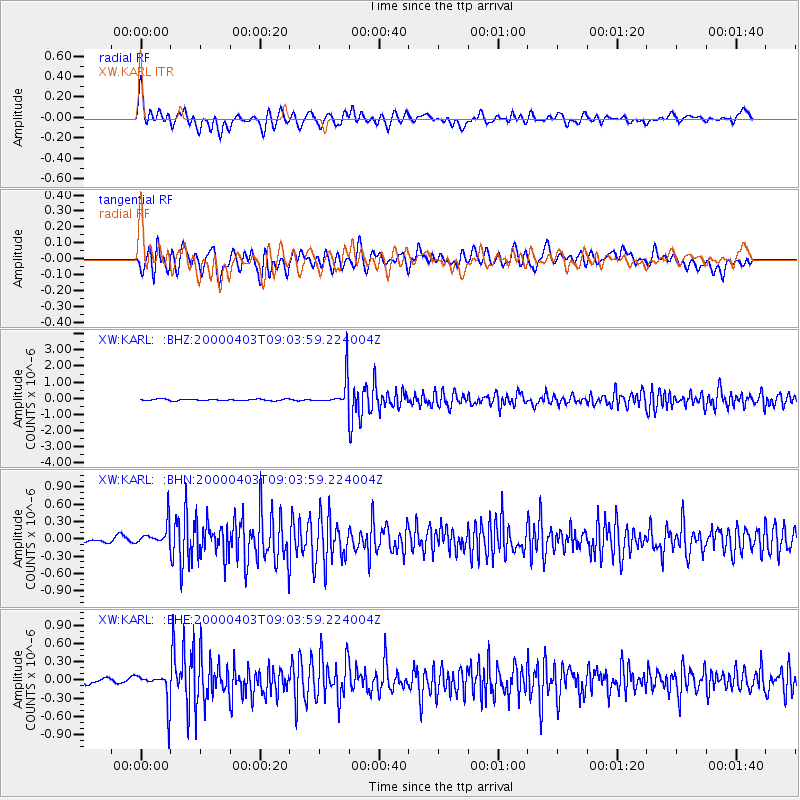
Signal To Noise
| Channel | StoN | STA | LTA |
| XW:KARL: :BHN:20000403T09:03:59.224004Z | 2.0555565 | 1.9282714E-7 | 9.3807756E-8 |
| XW:KARL: :BHE:20000403T09:03:59.224004Z | 3.5454311 | 2.6057802E-7 | 7.349686E-8 |
| XW:KARL: :BHZ:20000403T09:03:59.224004Z | 19.567148 | 8.9568334E-7 | 4.5774854E-8 |
| Arrivals |
| Ps | 3.0 SECOND |
| PpPs | 11 SECOND |
| PsPs/PpSs | 13 SECOND |


