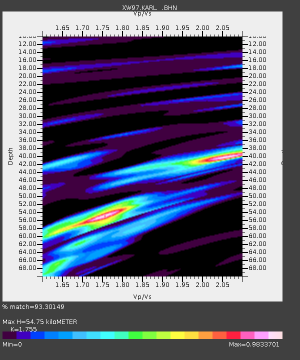
KARL XW.KARL - Earthquake Result Viewer
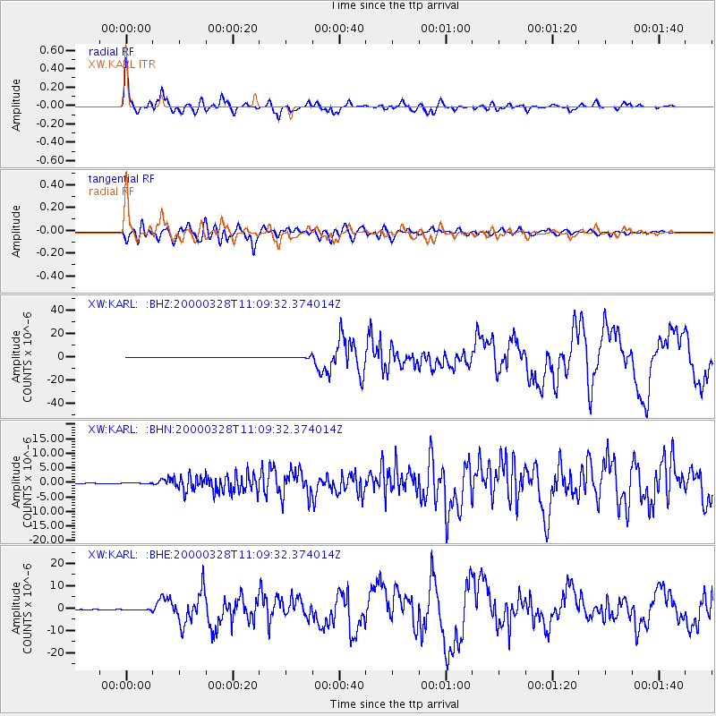
Earthquake location: Volcano Islands, Japan Region
Earthquake latitude/longitude: 22.3/143.7
Earthquake time(UTC): 2000/03/28 (088) 11:00:22 GMT
Earthquake Depth: 126 km
Earthquake Magnitude: 6.8 MB, 7.6 MS, 7.6 MW, 7.6 MW
Earthquake Catalog/Contributor: WHDF/NEIC
Network: XW Tien Shan Continental Dynamics
Station: KARL XW.KARL
Lat/Lon: 41.47 N/77.31 E
Elevation: 3021 m
Distance: 58.2 deg
Az: 305.829 deg
Baz: 87.327 deg
Ray Param: 0.06264414
Estimated Moho Depth: 54.75 km
Estimated Crust Vp/Vs: 1.75
Assumed Crust Vp: 6.491 km/s
Estimated Crust Vs: 3.699 km/s
Estimated Crust Poisson's Ratio: 0.26
Radial Match: 93.30149 %
Radial Bump: 400
Transverse Match: 90.77338 %
Transverse Bump: 400
SOD ConfigId: 20082
Insert Time: 2010-02-26 15:27:19.779 +0000
GWidth: 2.5
Max Bumps: 400
Tol: 0.001

Signal To Noise

ChannelStoNSTALTA
XW:KARL: :BHN:20000328T11:09:32.374014Z1.13588925.9433344E-85.232319E-8
XW:KARL: :BHE:20000328T11:09:32.374014Z3.27400612.2022147E-76.7263606E-8
XW:KARL: :BHZ:20000328T11:09:32.374014Z11.6520717.21188E-76.1893545E-8
Arrivals
Ps6.7 SECOND
PpPs22 SECOND
PsPs/PpSs29 SECOND