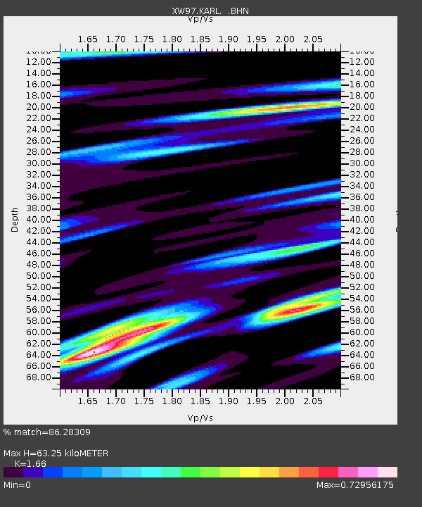
KARL XW.KARL - Earthquake Result Viewer
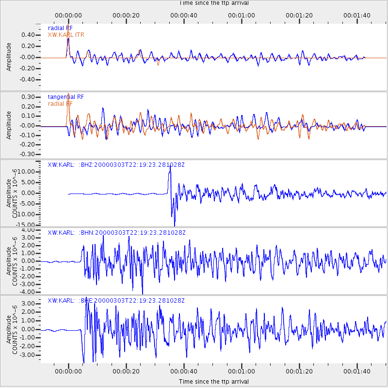
Earthquake location: Banda Sea
Earthquake latitude/longitude: -7.3/128.5
Earthquake time(UTC): 2000/03/03 (063) 22:09:13 GMT
Earthquake Depth: 142 km
Earthquake Magnitude: 6.4 MB, 5.8 MS, 6.3 MW, 6.3 MW
Earthquake Catalog/Contributor: WHDF/NEIC
Network: XW Tien Shan Continental Dynamics
Station: KARL XW.KARL
Lat/Lon: 41.47 N/77.31 E
Elevation: 3021 m
Distance: 67.4 deg
Az: 320.651 deg
Baz: 123.181 deg
Ray Param: 0.056572538
Estimated Moho Depth: 63.25 km
Estimated Crust Vp/Vs: 1.66
Assumed Crust Vp: 6.491 km/s
Estimated Crust Vs: 3.91 km/s
Estimated Crust Poisson's Ratio: 0.22
Radial Match: 86.28309 %
Radial Bump: 400
Transverse Match: 80.71045 %
Transverse Bump: 400
SOD ConfigId: 20082
Insert Time: 2010-02-26 15:27:23.101 +0000
GWidth: 2.5
Max Bumps: 400
Tol: 0.001

Signal To Noise

ChannelStoNSTALTA
XW:KARL: :BHN:20000303T22:19:23.281028Z7.895533.586759E-74.5427715E-8
XW:KARL: :BHE:20000303T22:19:23.281028Z7.867774.3345534E-75.5092528E-8
XW:KARL: :BHZ:20000303T22:19:23.281028Z14.1782932.0782263E-61.4657803E-7
Arrivals
Ps6.7 SECOND
PpPs25 SECOND
PsPs/PpSs32 SECOND