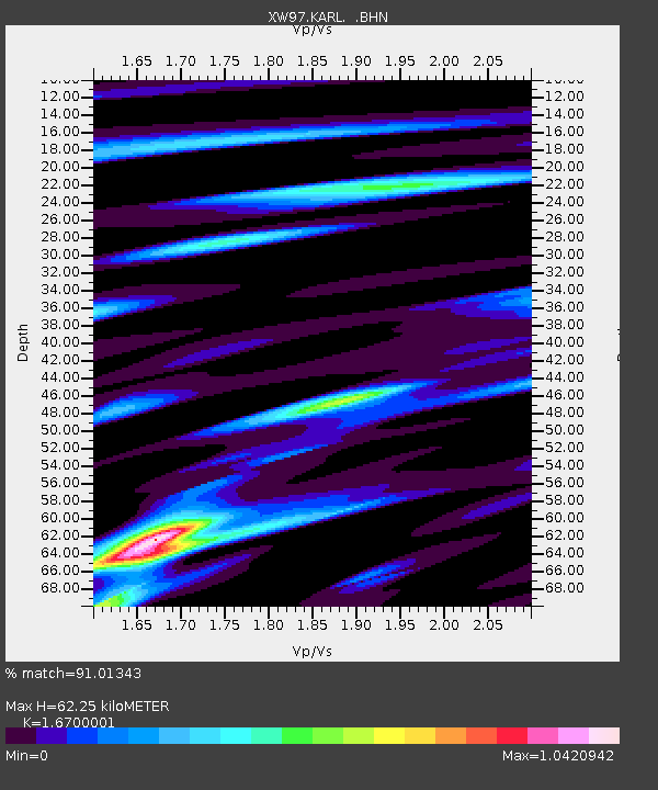
KARL XW.KARL - Earthquake Result Viewer
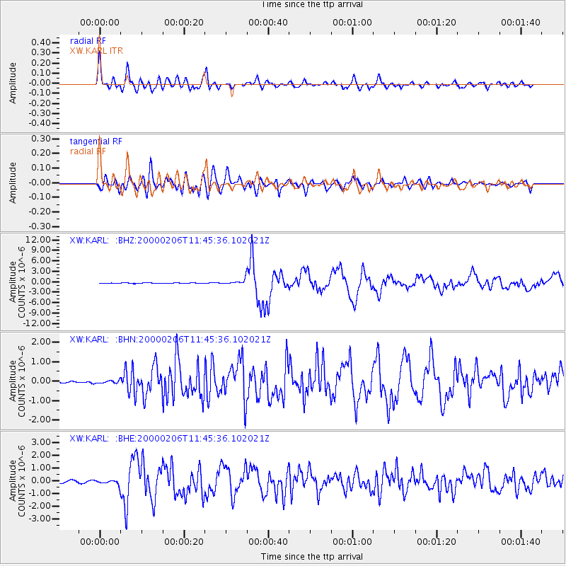
Earthquake location: New Britain Region, P.N.G.
Earthquake latitude/longitude: -5.8/150.9
Earthquake time(UTC): 2000/02/06 (037) 11:33:52 GMT
Earthquake Depth: 33 km
Earthquake Magnitude: 6.6 MB, 6.8 MS, 6.6 MW, 6.3 ME
Earthquake Catalog/Contributor: WHDF/NEIC
Network: XW Tien Shan Continental Dynamics
Station: KARL XW.KARL
Lat/Lon: 41.47 N/77.31 E
Elevation: 3021 m
Distance: 81.7 deg
Az: 313.244 deg
Baz: 105.336 deg
Ray Param: 0.0473742
Estimated Moho Depth: 62.25 km
Estimated Crust Vp/Vs: 1.67
Assumed Crust Vp: 6.491 km/s
Estimated Crust Vs: 3.887 km/s
Estimated Crust Poisson's Ratio: 0.22
Radial Match: 91.01343 %
Radial Bump: 400
Transverse Match: 85.99271 %
Transverse Bump: 400
SOD ConfigId: 20082
Insert Time: 2010-02-26 15:27:24.503 +0000
GWidth: 2.5
Max Bumps: 400
Tol: 0.001

Signal To Noise

ChannelStoNSTALTA
XW:KARL: :BHN:20000206T11:45:36.102021Z0.981597546.781986E-86.9091314E-8
XW:KARL: :BHE:20000206T11:45:36.102021Z2.8519671.9360627E-76.788517E-8
XW:KARL: :BHZ:20000206T11:45:36.102021Z9.9524957.7046457E-77.741422E-8
Arrivals
Ps6.6 SECOND
PpPs25 SECOND
PsPs/PpSs31 SECOND