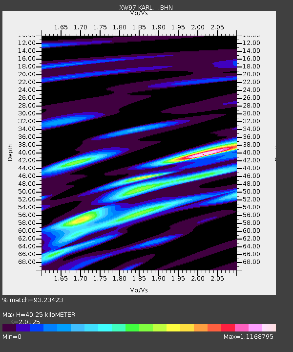
KARL XW.KARL - Earthquake Result Viewer

Earthquake location: Kuril Islands
Earthquake latitude/longitude: 43.0/146.8
Earthquake time(UTC): 2000/01/28 (028) 14:21:07 GMT
Earthquake Depth: 61 km
Earthquake Magnitude: 6.7 MB, 6.6 MS, 6.8 MW, 6.8 ME
Earthquake Catalog/Contributor: WHDF/NEIC
Network: XW Tien Shan Continental Dynamics
Station: KARL XW.KARL
Lat/Lon: 41.47 N/77.31 E
Elevation: 3021 m
Distance: 50.1 deg
Az: 293.418 deg
Baz: 63.533 deg
Ray Param: 0.06810614
Estimated Moho Depth: 40.25 km
Estimated Crust Vp/Vs: 2.01
Assumed Crust Vp: 6.491 km/s
Estimated Crust Vs: 3.225 km/s
Estimated Crust Poisson's Ratio: 0.34
Radial Match: 93.23423 %
Radial Bump: 400
Transverse Match: 87.04589 %
Transverse Bump: 400
SOD ConfigId: 20082
Insert Time: 2010-02-26 15:27:25.562 +0000
GWidth: 2.5
Max Bumps: 400
Tol: 0.001

Signal To Noise

ChannelStoNSTALTA
XW:KARL: :BHN:20000128T14:29:25.72501Z20.6437191.1432994E-65.5382433E-8
XW:KARL: :BHE:20000128T14:29:25.72501Z27.134691.9092197E-67.036085E-8
XW:KARL: :BHZ:20000128T14:29:25.72501Z59.5889855.037508E-68.453757E-8
Arrivals
Ps6.6 SECOND
PpPs18 SECOND
PsPs/PpSs24 SECOND