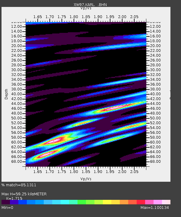
KARL XW.KARL - Earthquake Result Viewer
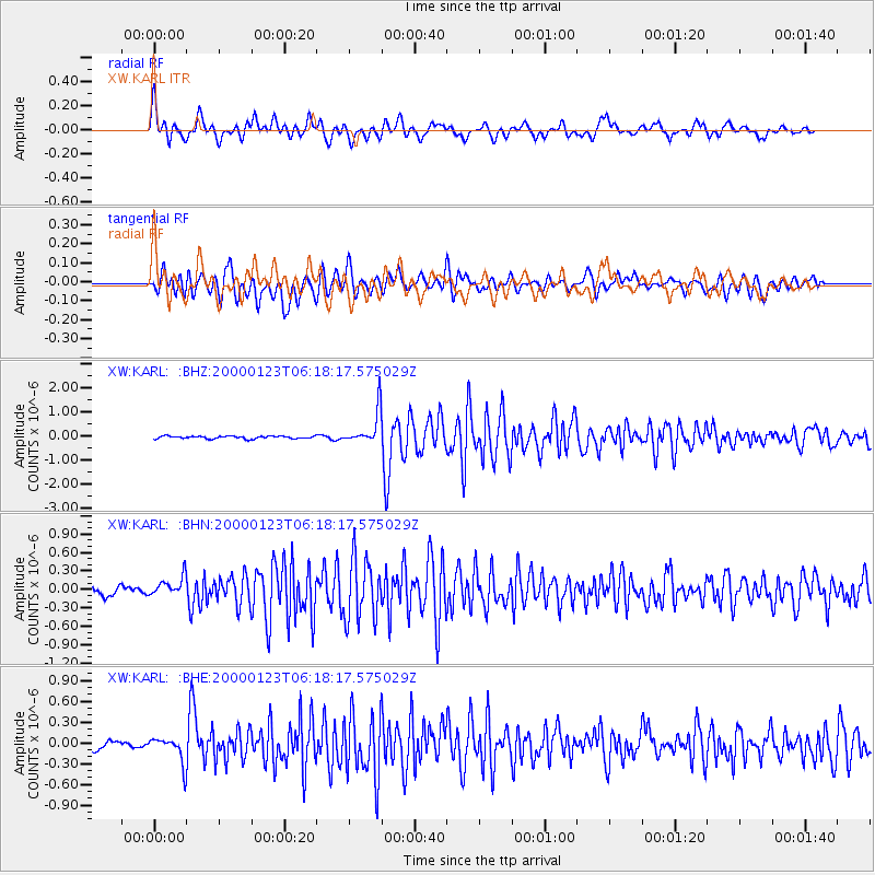
Earthquake location: Flores Sea
Earthquake latitude/longitude: -8.0/120.6
Earthquake time(UTC): 2000/01/23 (023) 06:08:24 GMT
Earthquake Depth: 47 km
Earthquake Magnitude: 5.7 MB, 5.2 MS, 5.8 MW, 5.7 MW
Earthquake Catalog/Contributor: WHDF/NEIC
Network: XW Tien Shan Continental Dynamics
Station: KARL XW.KARL
Lat/Lon: 41.47 N/77.31 E
Elevation: 3021 m
Distance: 63.2 deg
Az: 324.732 deg
Baz: 130.443 deg
Ray Param: 0.059631523
Estimated Moho Depth: 59.25 km
Estimated Crust Vp/Vs: 1.72
Assumed Crust Vp: 6.491 km/s
Estimated Crust Vs: 3.785 km/s
Estimated Crust Poisson's Ratio: 0.24
Radial Match: 85.1311 %
Radial Bump: 400
Transverse Match: 82.68677 %
Transverse Bump: 400
SOD ConfigId: 20082
Insert Time: 2010-02-26 15:27:27.429 +0000
GWidth: 2.5
Max Bumps: 400
Tol: 0.001

Signal To Noise

ChannelStoNSTALTA
XW:KARL: :BHN:20000123T06:18:17.575029Z3.08566741.564755E-75.0710426E-8
XW:KARL: :BHE:20000123T06:18:17.575029Z3.10734491.8359367E-75.9083778E-8
XW:KARL: :BHZ:20000123T06:18:17.575029Z12.6809356.915067E-75.453121E-8
Arrivals
Ps6.8 SECOND
PpPs24 SECOND
PsPs/PpSs31 SECOND