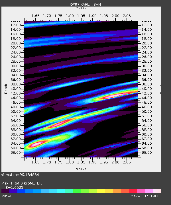
KARL XW.KARL - Earthquake Result Viewer
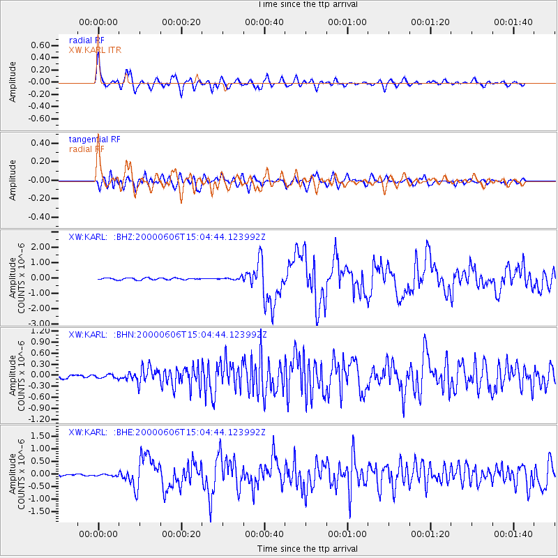
Earthquake location: Southeast Of Ryukyu Islands
Earthquake latitude/longitude: 29.4/131.4
Earthquake time(UTC): 2000/06/06 (158) 14:57:02 GMT
Earthquake Depth: 33 km
Earthquake Magnitude: 5.8 MB, 6.0 MS, 6.4 MW, 6.4 MW
Earthquake Catalog/Contributor: WHDF/NEIC
Network: XW Tien Shan Continental Dynamics
Station: KARL XW.KARL
Lat/Lon: 41.47 N/77.31 E
Elevation: 3021 m
Distance: 45.0 deg
Az: 300.616 deg
Baz: 87.58 deg
Ray Param: 0.07148203
Estimated Moho Depth: 64.0 km
Estimated Crust Vp/Vs: 1.65
Assumed Crust Vp: 6.491 km/s
Estimated Crust Vs: 3.928 km/s
Estimated Crust Poisson's Ratio: 0.21
Radial Match: 90.154854 %
Radial Bump: 400
Transverse Match: 76.44068 %
Transverse Bump: 400
SOD ConfigId: 3744
Insert Time: 2010-02-26 15:27:30.346 +0000
GWidth: 2.5
Max Bumps: 400
Tol: 0.001

Signal To Noise

ChannelStoNSTALTA
XW:KARL: :BHN:20000606T15:04:44.123992Z0.779144354.8512945E-86.226439E-8
XW:KARL: :BHE:20000606T15:04:44.123992Z1.54650894.223458E-82.7309625E-8
XW:KARL: :BHZ:20000606T15:04:44.123992Z1.38181888.136052E-85.8879298E-8
Arrivals
Ps6.9 SECOND
PpPs24 SECOND
PsPs/PpSs31 SECOND