You are here: Home > Network List > GE - GEOFON Stations List
> Station MAUI GEOFON Station Haleakala, Maui, Hawaii, USA > Earthquake Result Viewer
MAUI GEOFON Station Haleakala, Maui, Hawaii, USA - Earthquake Result Viewer
| Earthquake location: |
Tonga Islands |
| Earthquake latitude/longitude: |
-20.2/-174.1 |
| Earthquake time(UTC): |
2006/05/03 (123) 15:26:40 GMT |
| Earthquake Depth: |
55 km |
| Earthquake Magnitude: |
7.2 MB, 7.8 MS, 7.9 MW, 7.9 MW |
| Earthquake Catalog/Contributor: |
WHDF/NEIC |
|
| Network: |
GE GEOFON |
| Station: |
MAUI GEOFON Station Haleakala, Maui, Hawaii, USA |
| Lat/Lon: |
20.77 N/156.24 W |
| Elevation: |
2060 m |
|
| Distance: |
44.3 deg |
| Az: |
24.288 deg |
| Baz: |
204.385 deg |
| Ray Param: |
0.071850374 |
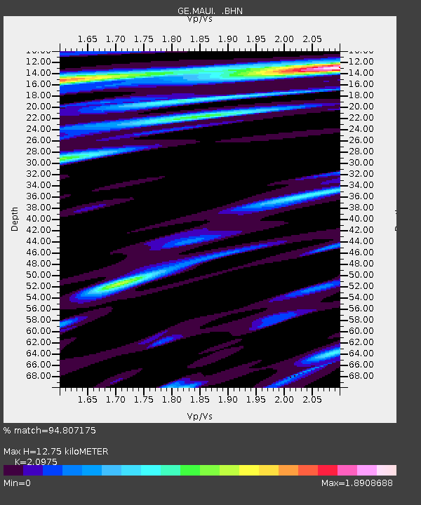
| Estimated Moho Depth: |
12.75 km |
| Estimated Crust Vp/Vs: |
2.10 |
| Assumed Crust Vp: |
5.265 km/s |
| Estimated Crust Vs: |
2.51 km/s |
| Estimated Crust Poisson's Ratio: |
0.35 |
|
| Radial Match: |
94.807175 % |
| Radial Bump: |
400 |
| Transverse Match: |
87.63116 % |
| Transverse Bump: |
400 |
| SOD ConfigId: |
2669 |
| Insert Time: |
2010-03-09 07:00:09.867 +0000 |
| GWidth: |
2.5 |
| Max Bumps: |
400 |
| Tol: |
0.001 |
|

Signal To Noise
| Channel | StoN | STA | LTA |
| GE:MAUI: :BHN:20060503T15:34:14.273002Z | 2.5945716 | 6.8393906E-6 | 2.6360385E-6 |
| GE:MAUI: :BHE:20060503T15:34:14.253013Z | 1.2300684 | 3.881555E-6 | 3.15556E-6 |
| GE:MAUI: :BHZ:20060503T15:34:14.243003Z | 3.4484158 | 8.285613E-6 | 2.4027304E-6 |
| Arrivals |
| Ps | 2.8 SECOND |
| PpPs | 7.2 SECOND |
| PsPs/PpSs | 10.0 SECOND |


