
Station GE MAUI - GEOFON Station Haleakala, Maui, Hawaii, USA
Network: GE - GEOFON
Nearby stations (2 deg radius)
| Station | Name | (Lat, Lon) | Start / End | Elevation |
| MAUI | GEOFON Station Haleakala, Maui, Hawaii, USA | (20.77, -156.24) | 2000-03-09 / 2499-01-01 | 2060 m |
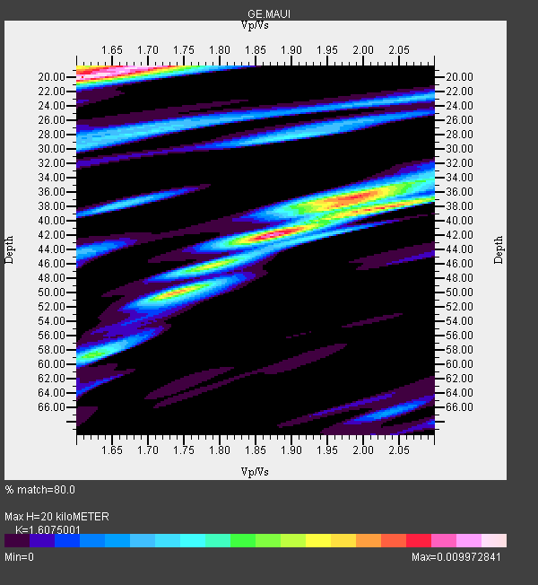
| Crust2 Type: | B5,thick melt affected o.c., no seds. |
| Thickness Estimate: | 20 km |
| Thickness StdDev: | 12 km |
| Vp/Vs Estimate: | 1.61 |
| Vp/Vs StdDev: | 0.15 |
| Vs Estimate: | 3.275 km/s |
| Poisson's Ratio: | 0.18 |
| Peak Value: | 0.01 |
| Assumed Vp: | 5.265 km/s |
| Ps Weight: | 0.33333334 |
| PpPs Weight: | 0.33333334 |
| PsPs Weight: | 0.33333328 |
| Residual Complexity: | 0.868 |
| Nearby stations H: | +- |
| (2.0 deg) Vp/Vs: | +- |
1 with match > 90% ( 5.882353 %) and 14 with match > 80% ( 82.35294 %) out of 17.
Download stack as xyz text file.
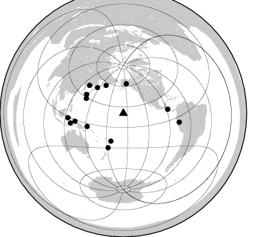
Azimuth Distribution of Events:
Prior Results for this Station
| Study | Thickness | Vp/Vs | Vp | Vs | Poissons Ratio | Extra |
| EARS | 20 km | 1.61 | 5.265 km/s | 3.275 km/s | 0.18 | |
| Crust2.0 | 24 km | 1.98 | 5.265 km/s | 2.664 km/s | 0.33 | B5,thick melt affected o.c., no seds. |
| Global Maxima | 20 km | 1.61 | 5.265 km/s | 3.275 km/s | 0.18 | amp=0.009972841 |
| Local Maxima 1 | 42 km | 1.87 | 5.265 km/s | 2.812 km/s | 0.30 | amp=0.009038393 |
| Local Maxima 2 | 38 km | 2.03 | 5.265 km/s | 2.6 km/s | 0.34 | amp=0.0077526746 |
| Local Maxima 3 | 18 km | 1.69 | 5.265 km/s | 3.125 km/s | 0.23 | amp=0.0062820194 |
| Local Maxima 4 | 37 km | 1.99 | 5.265 km/s | 2.652 km/s | 0.33 | amp=0.0057260375 |
| Predicted Arrivals for vertical incidence (zero ray parameter) | |
| Ps | 2.31 SECOND |
| PpPs | 9.90 SECOND |
| PsPs/PpSs | 12.21 SECOND |
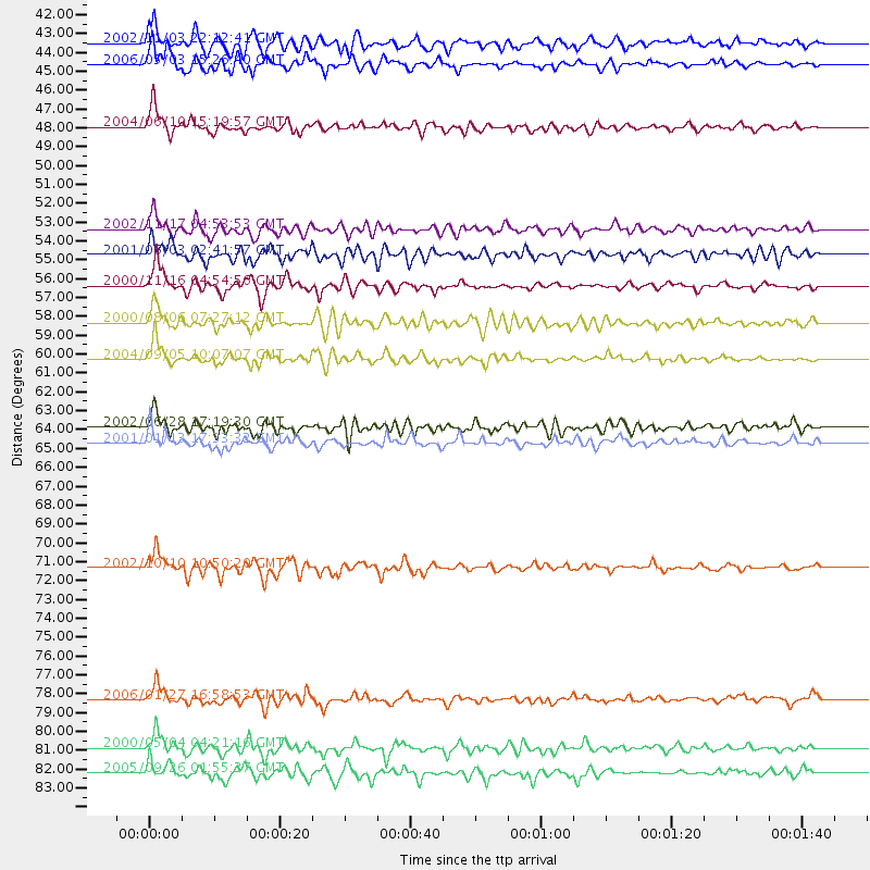
Events Processed for this Station
Download zip of receiver functions as SAC
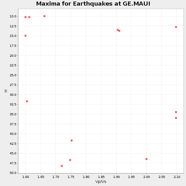
Plot maxima for each earthquake.
Events Used in the Stack
(14 events)| Radial Match | Distance | Baz | FERegion | Time | Lat/Lon | Depth | Magnitude |
| 94.807175 | 44.3 deg | 204.385 deg | Tonga Islands | 2006/05/03 15:26:40 GMT | (-20.2, -174.1) | 55 km | 7.2 MB, 7.8 MS, 7.9 MW, 7.9 MW |
| 89.534256 | 71.5 deg | 260.768 deg | Irian Jaya Region, Indonesia | 2002/10/10 10:50:20 GMT | (-1.8, 134.3) | 10 km | 6.5 MB, 7.7 MS, 7.6 MW, 7.4 MW |
| 89.51658 | 56.2 deg | 250.097 deg | New Ireland Region, P.N.G. | 2000/11/16 04:54:56 GMT | (-4.0, 152.2) | 33 km | 6.0 MB, 8.2 MS, 8.0 MW, 8.0 ME |
| 88.58861 | 64.7 deg | 84.991 deg | El Salvador | 2001/01/13 17:33:32 GMT | (13.0, -88.7) | 60 km | 6.4 MB, 7.8 MS, 7.7 MW, 7.5 ME |
| 87.381485 | 43.1 deg | 5.758 deg | Central Alaska | 2002/11/03 22:12:41 GMT | (63.5, -147.4) | 4.9 km | 7.0 MB, 8.5 MS, 7.9 MW |
| 87.18898 | 82.6 deg | 98.924 deg | Northern Peru | 2005/09/26 01:55:37 GMT | (-5.7, -76.4) | 115 km | 6.7 MB, 7.5 MW, 7.5 MW |
| 86.67005 | 81.2 deg | 265.472 deg | Sulawesi, Indonesia | 2000/05/04 04:21:16 GMT | (-1.1, 123.6) | 26 km | 6.7 MB, 7.5 MS, 7.6 MW, 7.5 ME |
| 86.01214 | 60.2 deg | 296.942 deg | Near S. Coast Of Western Honshu | 2004/09/05 10:07:07 GMT | (33.1, 136.6) | 14 km | 6.7 MB, 7.0 MS, 7.2 MW, 7.0 MW |
| 84.589294 | 63.9 deg | 309.453 deg | E. Russia-N.E. China Border Reg. | 2002/06/28 17:19:30 GMT | (43.8, 130.7) | 566 km | 6.7 MB, 7.3 MW, 7.3 MW |
| 84.425 | 47.7 deg | 328.01 deg | Kamchatka Peninsula, Russia | 2004/06/10 15:19:57 GMT | (55.7, 160.0) | 189 km | 6.1 MB, 6.9 MW, 6.9 MW |
| 83.67922 | 78.6 deg | 259.669 deg | Banda Sea | 2006/01/27 16:58:53 GMT | (-5.5, 128.1) | 397 km | 7.0 MB, 7.6 MW, 7.5 MW |
| 80.53917 | 54.6 deg | 204.002 deg | Kermadec Islands, New Zealand | 2001/06/03 02:41:57 GMT | (-29.7, -178.6) | 178 km | 6.8 MB, 7.2 MW, 7.1 MW |
| 80.28505 | 58.2 deg | 291.728 deg | Bonin Islands, Japan Region | 2000/08/06 07:27:12 GMT | (28.9, 139.6) | 395 km | 6.3 MB, 7.3 MW, 7.3 MW |
| 80.17646 | 53.2 deg | 314.763 deg | Northwest Of Kuril Islands | 2002/11/17 04:53:53 GMT | (47.8, 146.2) | 459 km | 7.3 MW, 7.3 MW |
Losers
(3 events)| Radial Match | Distance | Baz | FERegion | Time | Lat/Lon | Depth | Magnitude | Reason |
| 90.16714 | 52.4 deg | 237.762 deg | Solomon Islands | 2003/01/20 08:43:06 GMT | (-10.5, 160.8) | 33 km | 6.7 MB, 7.8 MS, 7.3 MW, 7.2 MW | |
| 66.54844 | 67.6 deg | 86.064 deg | Near Coast Of Nicaragua | 2005/07/02 02:16:43 GMT | (11.2, -86.2) | 27 km | 5.6 MB, 6.4 MS, 6.6 MW, 6.6 MW | |
| 65.90561 | 48.3 deg | 314.248 deg | Kuril Islands | 2008/03/03 09:31:02 GMT | (46.4, 153.2) | 10 km | 6.2 MB, 6.5 MS, 6.5 MW, 6.5 MW |
