You are here: Home > Network List > GE - GEOFON Stations List
> Station MAUI GEOFON Station Haleakala, Maui, Hawaii, USA > Earthquake Result Viewer
MAUI GEOFON Station Haleakala, Maui, Hawaii, USA - Earthquake Result Viewer
| Earthquake location: |
Bonin Islands, Japan Region |
| Earthquake latitude/longitude: |
28.9/139.6 |
| Earthquake time(UTC): |
2000/08/06 (219) 07:27:12 GMT |
| Earthquake Depth: |
395 km |
| Earthquake Magnitude: |
6.3 MB, 7.3 MW, 7.3 MW |
| Earthquake Catalog/Contributor: |
WHDF/NEIC |
|
| Network: |
GE GEOFON |
| Station: |
MAUI GEOFON Station Haleakala, Maui, Hawaii, USA |
| Lat/Lon: |
20.77 N/156.24 W |
| Elevation: |
2060 m |
|
| Distance: |
58.2 deg |
| Az: |
82.318 deg |
| Baz: |
291.728 deg |
| Ray Param: |
0.061526466 |
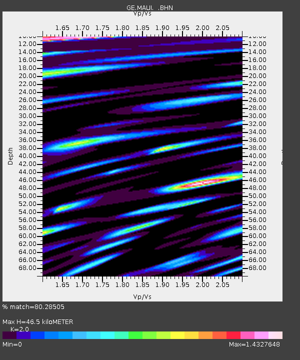
| Estimated Moho Depth: |
46.5 km |
| Estimated Crust Vp/Vs: |
2.00 |
| Assumed Crust Vp: |
5.265 km/s |
| Estimated Crust Vs: |
2.633 km/s |
| Estimated Crust Poisson's Ratio: |
0.33 |
|
| Radial Match: |
80.28505 % |
| Radial Bump: |
400 |
| Transverse Match: |
73.03226 % |
| Transverse Bump: |
400 |
| SOD ConfigId: |
3744 |
| Insert Time: |
2010-03-09 07:00:11.949 +0000 |
| GWidth: |
2.5 |
| Max Bumps: |
400 |
| Tol: |
0.001 |
|

Signal To Noise
| Channel | StoN | STA | LTA |
| GE:MAUI: :BHN:20000806T07:35:56.751013Z | 1.1074725 | 1.4123592E-6 | 1.2752995E-6 |
| GE:MAUI: :BHE:20000806T07:35:56.751013Z | 0.879085 | 1.6379079E-6 | 1.8631963E-6 |
| GE:MAUI: :BHZ:20000806T07:35:56.751013Z | 4.990308 | 5.675568E-6 | 1.1373181E-6 |
| Arrivals |
| Ps | 9.1 SECOND |
| PpPs | 26 SECOND |
| PsPs/PpSs | 35 SECOND |


