You are here: Home > Network List > GE - GEOFON Stations List
> Station MAUI GEOFON Station Haleakala, Maui, Hawaii, USA > Earthquake Result Viewer
MAUI GEOFON Station Haleakala, Maui, Hawaii, USA - Earthquake Result Viewer
| Earthquake location: |
E. Russia-N.E. China Border Reg. |
| Earthquake latitude/longitude: |
43.8/130.7 |
| Earthquake time(UTC): |
2002/06/28 (179) 17:19:30 GMT |
| Earthquake Depth: |
566 km |
| Earthquake Magnitude: |
6.7 MB, 7.3 MW, 7.3 MW |
| Earthquake Catalog/Contributor: |
WHDF/NEIC |
|
| Network: |
GE GEOFON |
| Station: |
MAUI GEOFON Station Haleakala, Maui, Hawaii, USA |
| Lat/Lon: |
20.77 N/156.24 W |
| Elevation: |
2060 m |
|
| Distance: |
63.9 deg |
| Az: |
85.667 deg |
| Baz: |
309.453 deg |
| Ray Param: |
0.057165716 |
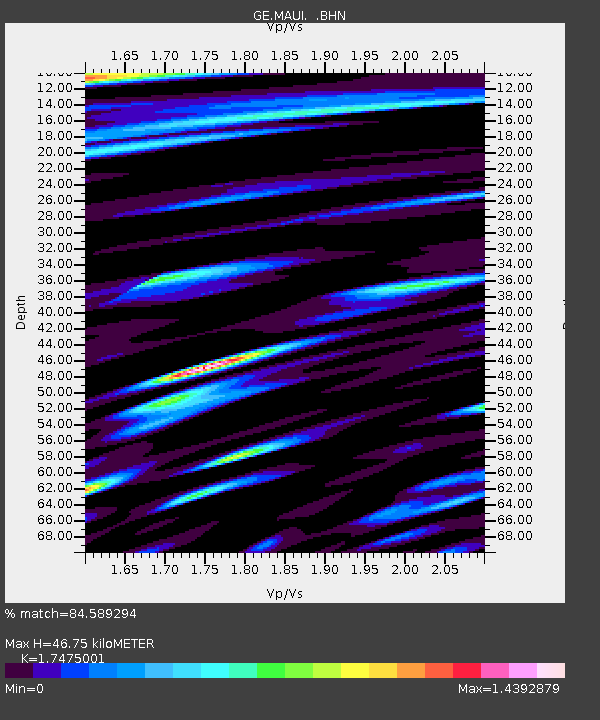
| Estimated Moho Depth: |
46.75 km |
| Estimated Crust Vp/Vs: |
1.75 |
| Assumed Crust Vp: |
5.265 km/s |
| Estimated Crust Vs: |
3.013 km/s |
| Estimated Crust Poisson's Ratio: |
0.26 |
|
| Radial Match: |
84.589294 % |
| Radial Bump: |
400 |
| Transverse Match: |
80.260735 % |
| Transverse Bump: |
400 |
| SOD ConfigId: |
20082 |
| Insert Time: |
2010-03-09 07:00:16.722 +0000 |
| GWidth: |
2.5 |
| Max Bumps: |
400 |
| Tol: |
0.001 |
|

Signal To Noise
| Channel | StoN | STA | LTA |
| GE:MAUI: :BHN:20020628T17:28:37.136028Z | 1.3327756 | 3.3284866E-6 | 2.4974097E-6 |
| GE:MAUI: :BHE:20020628T17:28:37.136028Z | 0.93355894 | 3.1195175E-6 | 3.3415324E-6 |
| GE:MAUI: :BHZ:20020628T17:28:37.136028Z | 5.106162 | 1.04370365E-5 | 2.0440082E-6 |
| Arrivals |
| Ps | 6.8 SECOND |
| PpPs | 24 SECOND |
| PsPs/PpSs | 31 SECOND |


