You are here: Home > Network List > XW97 - Tien Shan Continental Dynamics Stations List
> Station KAZ XW.KAZ > Earthquake Result Viewer
KAZ XW.KAZ - Earthquake Result Viewer
| Earthquake location: |
Southeast Of Honshu, Japan |
| Earthquake latitude/longitude: |
30.5/137.7 |
| Earthquake time(UTC): |
2000/06/09 (161) 23:31:45 GMT |
| Earthquake Depth: |
485 km |
| Earthquake Magnitude: |
5.9 MB, 6.3 MW, 6.2 MW |
| Earthquake Catalog/Contributor: |
WHDF/NEIC |
|
| Network: |
XW Tien Shan Continental Dynamics |
| Station: |
KAZ XW.KAZ |
| Lat/Lon: |
41.38 N/73.94 E |
| Elevation: |
1404 m |
|
| Distance: |
51.7 deg |
| Az: |
300.691 deg |
| Baz: |
80.558 deg |
| Ray Param: |
0.06515149 |
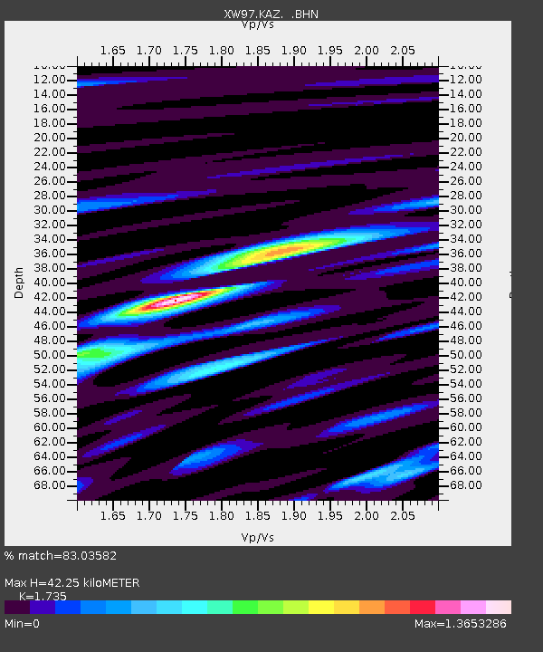
| Estimated Moho Depth: |
42.25 km |
| Estimated Crust Vp/Vs: |
1.74 |
| Assumed Crust Vp: |
6.306 km/s |
| Estimated Crust Vs: |
3.635 km/s |
| Estimated Crust Poisson's Ratio: |
0.25 |
|
| Radial Match: |
83.03582 % |
| Radial Bump: |
400 |
| Transverse Match: |
66.91935 % |
| Transverse Bump: |
400 |
| SOD ConfigId: |
20082 |
| Insert Time: |
2010-02-26 15:29:29.916 +0000 |
| GWidth: |
2.5 |
| Max Bumps: |
400 |
| Tol: |
0.001 |
|
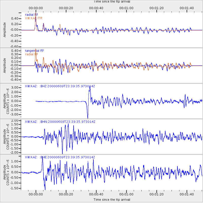
Signal To Noise
| Channel | StoN | STA | LTA |
| XW:KAZ: :BHN:20000609T23:39:35.973014Z | 1.8186687 | 5.719519E-8 | 3.1448934E-8 |
| XW:KAZ: :BHE:20000609T23:39:35.973014Z | 12.606222 | 4.3434937E-7 | 3.445516E-8 |
| XW:KAZ: :BHZ:20000609T23:39:35.973014Z | 27.735083 | 1.1509004E-6 | 4.1496197E-8 |
| Arrivals |
| Ps | 5.2 SECOND |
| PpPs | 17 SECOND |
| PsPs/PpSs | 23 SECOND |


