KAZ XW.KAZ - Earthquake Result Viewer
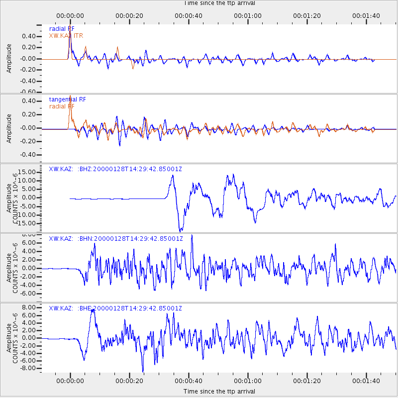
Earthquake location: Kuril Islands
Earthquake latitude/longitude: 43.0/146.8
Earthquake time(UTC): 2000/01/28 (028) 14:21:07 GMT
Earthquake Depth: 61 km
Earthquake Magnitude: 6.7 MB, 6.6 MS, 6.8 MW, 6.8 ME
Earthquake Catalog/Contributor: WHDF/NEIC
Network: XW Tien Shan Continental Dynamics
Station: KAZ XW.KAZ
Lat/Lon: 41.38 N/73.94 E
Elevation: 1404 m
Distance: 52.4 deg
Az: 294.798 deg
Baz: 62.177 deg
Ray Param: 0.0666236
Estimated Moho Depth: 50.25 km
Estimated Crust Vp/Vs: 1.60
Assumed Crust Vp: 6.306 km/s
Estimated Crust Vs: 3.935 km/s
Estimated Crust Poisson's Ratio: 0.18
Radial Match: 89.57272 %
Radial Bump: 400
Transverse Match: 58.04658 %
Transverse Bump: 400
SOD ConfigId: 20082
Insert Time: 2010-02-26 15:29:59.960 +0000
GWidth: 2.5
Max Bumps: 400
Tol: 0.001

Signal To Noise

ChannelStoNSTALTA
XW:KAZ: :BHN:20000128T14:29:42.85001Z16.1097851.0396262E-66.4533836E-8
XW:KAZ: :BHE:20000128T14:29:42.85001Z40.5677572.1442177E-65.285522E-8
XW:KAZ: :BHZ:20000128T14:29:42.85001Z55.699265.519961E-69.9102955E-8
Arrivals
Ps5.1 SECOND
PpPs20 SECOND
PsPs/PpSs25 SECOND