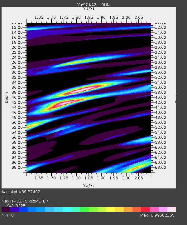
KAZ XW.KAZ - Earthquake Result Viewer
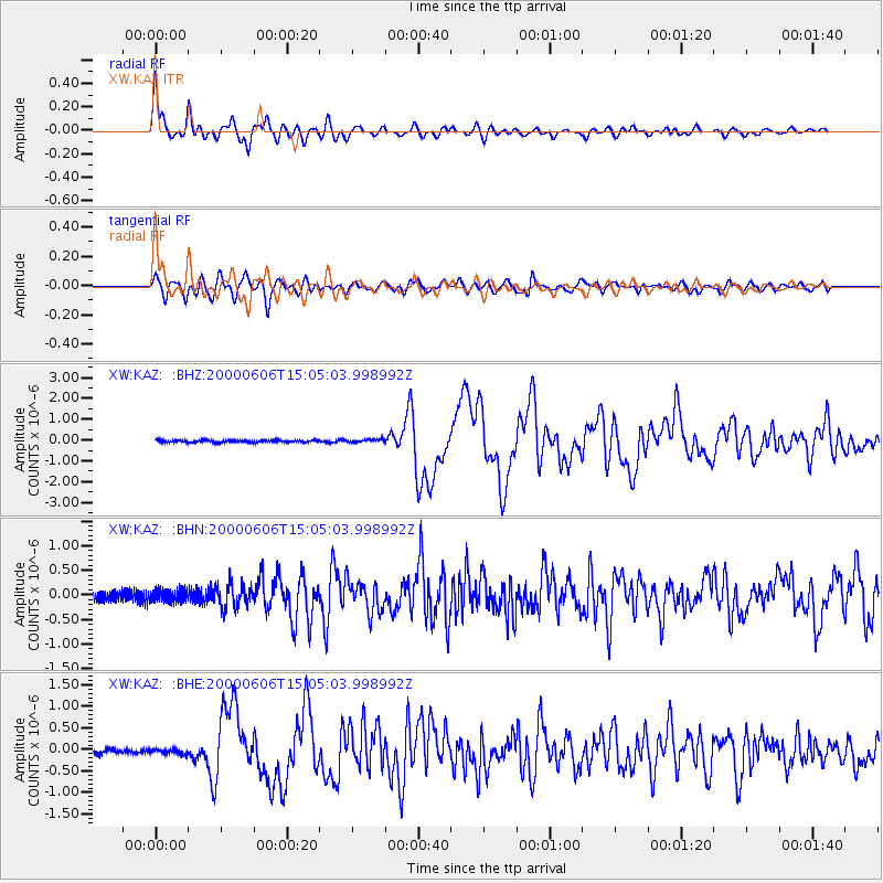
Earthquake location: Southeast Of Ryukyu Islands
Earthquake latitude/longitude: 29.4/131.4
Earthquake time(UTC): 2000/06/06 (158) 14:57:02 GMT
Earthquake Depth: 33 km
Earthquake Magnitude: 5.8 MB, 6.0 MS, 6.4 MW, 6.4 MW
Earthquake Catalog/Contributor: WHDF/NEIC
Network: XW Tien Shan Continental Dynamics
Station: KAZ XW.KAZ
Lat/Lon: 41.38 N/73.94 E
Elevation: 1404 m
Distance: 47.6 deg
Az: 300.708 deg
Baz: 85.424 deg
Ray Param: 0.069849156
Estimated Moho Depth: 36.75 km
Estimated Crust Vp/Vs: 1.82
Assumed Crust Vp: 6.306 km/s
Estimated Crust Vs: 3.46 km/s
Estimated Crust Poisson's Ratio: 0.28
Radial Match: 89.87602 %
Radial Bump: 400
Transverse Match: 79.777596 %
Transverse Bump: 400
SOD ConfigId: 3744
Insert Time: 2010-02-26 15:30:04.655 +0000
GWidth: 2.5
Max Bumps: 400
Tol: 0.001

Signal To Noise

ChannelStoNSTALTA
XW:KAZ: :BHN:20000606T15:05:03.998992Z1.01497281.2514943E-71.2330324E-7
XW:KAZ: :BHE:20000606T15:05:03.998992Z0.8466515.3183914E-86.281681E-8
XW:KAZ: :BHZ:20000606T15:05:03.998992Z1.33934387.264899E-85.424223E-8
Arrivals
Ps5.1 SECOND
PpPs16 SECOND
PsPs/PpSs21 SECOND