You are here: Home > Network List > XR97 - INDEPTH III Stations List
> Station ST09 South Palgon > Earthquake Result Viewer
ST09 South Palgon - Earthquake Result Viewer
| Earthquake location: |
Solomon Islands |
| Earthquake latitude/longitude: |
-9.3/158.7 |
| Earthquake time(UTC): |
1997/10/06 (279) 20:52:44 GMT |
| Earthquake Depth: |
33 km |
| Earthquake Magnitude: |
5.7 MB, 5.9 MS, 6.1 UNKNOWN, 6.1 MW |
| Earthquake Catalog/Contributor: |
WHDF/NEIC |
|
| Network: |
XR INDEPTH III |
| Station: |
ST09 South Palgon |
| Lat/Lon: |
31.42 N/90.00 E |
| Elevation: |
4745 m |
|
| Distance: |
77.1 deg |
| Az: |
305.206 deg |
| Baz: |
109.377 deg |
| Ray Param: |
0.050510347 |
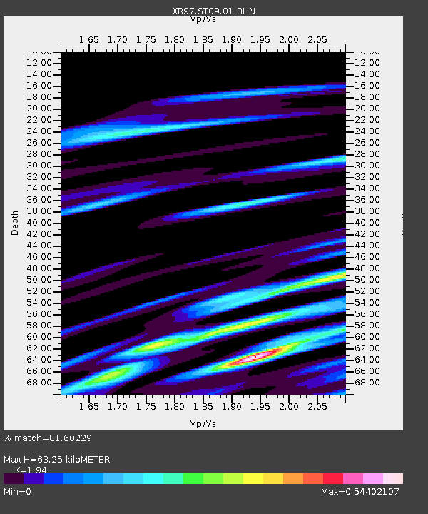
| Estimated Moho Depth: |
63.25 km |
| Estimated Crust Vp/Vs: |
1.94 |
| Assumed Crust Vp: |
6.5 km/s |
| Estimated Crust Vs: |
3.351 km/s |
| Estimated Crust Poisson's Ratio: |
0.32 |
|
| Radial Match: |
81.60229 % |
| Radial Bump: |
400 |
| Transverse Match: |
63.107243 % |
| Transverse Bump: |
400 |
| SOD ConfigId: |
6273 |
| Insert Time: |
2010-03-09 08:04:07.938 +0000 |
| GWidth: |
2.5 |
| Max Bumps: |
400 |
| Tol: |
0.001 |
|

Signal To Noise
| Channel | StoN | STA | LTA |
| XR:ST09:01:BHN:19971006T21:04:03.550012Z | 0.5042307 | 4.413007E-8 | 8.751961E-8 |
| XR:ST09:01:BHE:19971006T21:04:03.550012Z | 0.45594636 | 2.7913405E-8 | 6.122081E-8 |
| XR:ST09:01:BHZ:19971006T21:04:03.550012Z | 1.458821 | 2.613643E-7 | 1.791613E-7 |
| Arrivals |
| Ps | 9.4 SECOND |
| PpPs | 28 SECOND |
| PsPs/PpSs | 37 SECOND |


