
Station XR ST09 - South Palgon
Network: XR97 - INDEPTH III
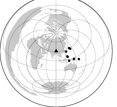
Nearby stations (2 deg radius)

| Station | Name | (Lat, Lon) | Start / End | Elevation |
| ST09 | South Palgon | (31.42, 90.00) | 1997-07-19 / 1999-12-31 | 4745 m |
| Crust2 Type: | R5,orogen/75km Tibet, 0 km seds. |
| Thickness Estimate: | 62 km |
| Thickness StdDev: | 10.0 km |
| Vp/Vs Estimate: | 1.66 |
| Vp/Vs StdDev: | 0.17 |
| Vs Estimate: | 3.904 km/s |
| Poisson's Ratio: | 0.22 |
| Peak Value: | 0.01 |
| Assumed Vp: | 6.5 km/s |
| Ps Weight: | 0.33333334 |
| PpPs Weight: | 0.33333334 |
| PsPs Weight: | 0.33333328 |
| Residual Complexity: | 0.843 |
| Nearby stations H: | +- |
| (2.0 deg) Vp/Vs: | +- |
5 with match > 90% ( 62.5 %) and 8 with match > 80% ( 100.0 %) out of 8.
Download stack as xyz text file.
Azimuth Distribution of Events:
Prior Results for this Station
| Study | Thickness | Vp/Vs | Vp | Vs | Poissons Ratio | Extra |
| EARS | 62 km | 1.66 | 6.5 km/s | 3.904 km/s | 0.22 | |
| Crust2.0 | 75 km | 1.76 | 6.5 km/s | 3.7 km/s | 0.26 | R5,orogen/75km Tibet, 0 km seds. |
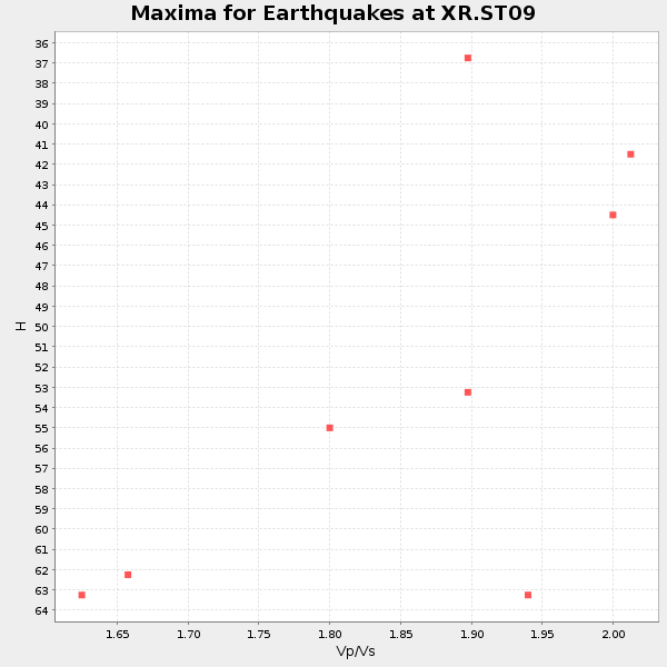
| Global Maxima | 62 km | 1.66 | 6.5 km/s | 3.904 km/s | 0.22 | amp=0.009542497 |
| Local Maxima 1 | 66 km | 2.03 | 6.5 km/s | 3.202 km/s | 0.34 | amp=0.009540271 |
| Local Maxima 2 | 43 km | 2.10 | 6.5 km/s | 3.099 km/s | 0.35 | amp=0.007393683 |
| Local Maxima 3 | 48 km | 2.10 | 6.5 km/s | 3.099 km/s | 0.35 | amp=0.0070776157 |
| Local Maxima 4 | 47 km | 1.91 | 6.5 km/s | 3.394 km/s | 0.31 | amp=0.00663088 |
| Predicted Arrivals for vertical incidence (zero ray parameter) | |
| Ps | 6.34 SECOND |
| PpPs | 25.42 SECOND |
| PsPs/PpSs | 31.76 SECOND |
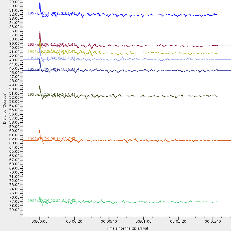
Events Processed for this Station
Download zip of receiver functions as SAC
Plot maxima for each earthquake.
Events Used in the Stack
(8 events)| Radial Match | Distance | Baz | FERegion | Time | Lat/Lon | Depth | Magnitude |
| 93.385506 | 41.2 deg | 116.34 deg | Mindanao, Philippines | 1997/09/15 13:05:42 GMT | (8.1, 126.6) | 51 km | 5.8 MB, 5.7 MS, 6.1 UNKNOWN, 6.1 MW |
| 92.90567 | 39.5 deg | 115.142 deg | Mindanao, Philippines | 1997/10/06 12:30:05 GMT | (9.8, 125.8) | 106 km | 5.9 MB, 6.5 UNKNOWN, 6.4 MW |
| 91.9841 | 42.8 deg | 76.591 deg | Southeast Of Honshu, Japan | 1997/11/10 23:06:44 GMT | (31.2, 140.5) | 86 km | 5.8 MB, 6.1 UNKNOWN, 6.1 MW |
| 91.870804 | 62.3 deg | 113.607 deg | Near N Coast Of New Guinea, P.N.G. | 1997/08/29 08:14:09 GMT | (-3.6, 144.4) | 23 km | 5.8 MB, 6.8 MS, 6.6 UNKNOWN, 6.5 MW |
| 90.98791 | 51.6 deg | 126.661 deg | Banda Sea | 1998/02/19 14:14:51 GMT | (-4.5, 129.1) | 33 km | 6.1 MB, 6.4 MS, 6.5 UNKNOWN, 6.5 MW |
| 86.48103 | 32.1 deg | 92.393 deg | Southwestern Ryukyu Isl., Japan | 1997/08/13 04:45:04 GMT | (25.0, 125.8) | 55 km | 6.0 MB, 5.6 MS, 6.1 UNKNOWN, 6.1 MW |
| 84.842995 | 45.5 deg | 80.435 deg | Bonin Islands, Japan Region | 1997/11/05 23:45:30 GMT | (27.9, 142.6) | 10 km | 5.4 MB, 5.6 MS, 6.0 UNKNOWN, 5.9 MW |
| 81.60229 | 77.1 deg | 109.377 deg | Solomon Islands | 1997/10/06 20:52:44 GMT | (-9.3, 158.7) | 33 km | 5.7 MB, 5.9 MS, 6.1 UNKNOWN, 6.1 MW |
Losers
(0 events)| Radial Match | Distance | Baz | FERegion | Time | Lat/Lon | Depth | Magnitude | Reason |
