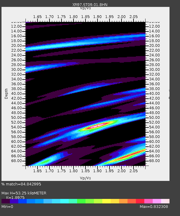
ST09 South Palgon - Earthquake Result Viewer

Earthquake location: Bonin Islands, Japan Region
Earthquake latitude/longitude: 27.9/142.6
Earthquake time(UTC): 1997/11/05 (309) 23:45:30 GMT
Earthquake Depth: 10 km
Earthquake Magnitude: 5.4 MB, 5.6 MS, 6.0 UNKNOWN, 5.9 MW
Earthquake Catalog/Contributor: WHDF/NEIC
Network: XR INDEPTH III
Station: ST09 South Palgon
Lat/Lon: 31.42 N/90.00 E
Elevation: 4745 m
Distance: 45.5 deg
Az: 287.788 deg
Baz: 80.435 deg
Ray Param: 0.07123533
Estimated Moho Depth: 53.25 km
Estimated Crust Vp/Vs: 1.90
Assumed Crust Vp: 6.5 km/s
Estimated Crust Vs: 3.426 km/s
Estimated Crust Poisson's Ratio: 0.31
Radial Match: 84.842995 %
Radial Bump: 301
Transverse Match: 70.8506 %
Transverse Bump: 400
SOD ConfigId: 6273
Insert Time: 2010-03-09 08:04:09.312 +0000
GWidth: 2.5
Max Bumps: 400
Tol: 0.001

Signal To Noise

ChannelStoNSTALTA
XR:ST09:01:BHN:19971105T23:53:19.257007Z1.03647267.9656864E-87.68538E-8
XR:ST09:01:BHE:19971105T23:53:19.257007Z2.91160352.412546E-78.2859714E-8
XR:ST09:01:BHZ:19971105T23:53:19.257007Z5.61439374.623476E-78.2350404E-8
Arrivals
Ps7.8 SECOND
PpPs22 SECOND
PsPs/PpSs30 SECOND