You are here: Home > Network List > XR94 - INDEPTH II Stations List
> Station BB05 Ningchung > Earthquake Result Viewer
BB05 Ningchung - Earthquake Result Viewer
| Earthquake location: |
East Of Kuril Islands |
| Earthquake latitude/longitude: |
44.7/150.2 |
| Earthquake time(UTC): |
1994/08/28 (240) 18:37:19 GMT |
| Earthquake Depth: |
14 km |
| Earthquake Magnitude: |
6.0 MB, 6.5 MS, 6.3 UNKNOWN, 6.7 MW |
| Earthquake Catalog/Contributor: |
WHDF/NEIC |
|
| Network: |
XR INDEPTH II |
| Station: |
BB05 Ningchung |
| Lat/Lon: |
30.38 N/90.91 E |
| Elevation: |
4219 m |
|
| Distance: |
48.1 deg |
| Az: |
273.785 deg |
| Baz: |
55.42 deg |
| Ray Param: |
0.069559604 |
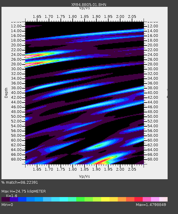
| Estimated Moho Depth: |
24.75 km |
| Estimated Crust Vp/Vs: |
1.60 |
| Assumed Crust Vp: |
6.5 km/s |
| Estimated Crust Vs: |
4.062 km/s |
| Estimated Crust Poisson's Ratio: |
0.18 |
|
| Radial Match: |
86.22391 % |
| Radial Bump: |
400 |
| Transverse Match: |
67.51377 % |
| Transverse Bump: |
400 |
| SOD ConfigId: |
17000 |
| Insert Time: |
2010-03-09 08:04:37.792 +0000 |
| GWidth: |
2.5 |
| Max Bumps: |
400 |
| Tol: |
0.001 |
|

Signal To Noise
| Channel | StoN | STA | LTA |
| XR:BB05:01:BHN:19940828T18:45:27.964008Z | 2.7526906 | 1.6385701E-7 | 5.9526126E-8 |
| XR:BB05:01:BHE:19940828T18:45:27.964008Z | 2.187623 | 1.354506E-7 | 6.191679E-8 |
| XR:BB05:01:BHZ:19940828T18:45:27.964008Z | 6.07234 | 3.832766E-7 | 6.3118435E-8 |
| Arrivals |
| Ps | 2.4 SECOND |
| PpPs | 9.2 SECOND |
| PsPs/PpSs | 12 SECOND |


