
Station XR BB05 - Ningchung
Network: XR94 - INDEPTH II
Nearby stations (2 deg radius)
| Station | Name | (Lat, Lon) | Start / End | Elevation |
| BB05 | Ningchung | (30.38, 90.91) | 1994-06-05 / 1994-12-31 | 4219 m |
| Crust2 Type: | R5,orogen/75km Tibet, 0 km seds. |
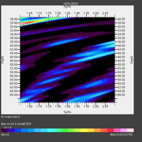
| Thickness Estimate: | 28 km |
| Thickness StdDev: | 1.5 km |
| Vp/Vs Estimate: | 1.60 |
| Vp/Vs StdDev: | 0.05 |
| Vs Estimate: | 4.062 km/s |
| Poisson's Ratio: | 0.18 |
| Peak Value: | 0.05 |
| Assumed Vp: | 6.5 km/s |
| Ps Weight: | 0.33333334 |
| PpPs Weight: | 0.33333334 |
| PsPs Weight: | 0.33333328 |
| Residual Complexity: | 0.729 |
| Nearby stations H: | +- |
| (2.0 deg) Vp/Vs: | +- |
4 with match > 90% ( 25.0 %) and 16 with match > 80% ( 100.0 %) out of 16.
Download stack as xyz text file.
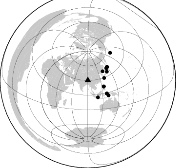
Azimuth Distribution of Events:
Prior Results for this Station
| Study | Thickness | Vp/Vs | Vp | Vs | Poissons Ratio | Extra |
| EARS | 28 km | 1.60 | 6.5 km/s | 4.062 km/s | 0.18 | |
| Crust2.0 | 75 km | 1.76 | 6.5 km/s | 3.7 km/s | 0.26 | R5,orogen/75km Tibet, 0 km seds. |
| Global Maxima | 28 km | 1.60 | 6.5 km/s | 4.062 km/s | 0.18 | amp=0.05324765 |
| Local Maxima 1 | 25 km | 1.60 | 6.5 km/s | 4.062 km/s | 0.18 | amp=0.02751485 |
| Local Maxima 2 | 38 km | 2.10 | 6.5 km/s | 3.099 km/s | 0.35 | amp=0.024388377 |
| Local Maxima 3 | 45 km | 2.01 | 6.5 km/s | 3.23 km/s | 0.34 | amp=0.021115111 |
| Local Maxima 4 | 25 km | 1.80 | 6.5 km/s | 3.611 km/s | 0.28 | amp=0.019059135 |
| Predicted Arrivals for vertical incidence (zero ray parameter) | |
| Ps | 2.63 SECOND |
| PpPs | 11.40 SECOND |
| PsPs/PpSs | 14.03 SECOND |
Events Processed for this Station
Download zip of receiver functions as SAC
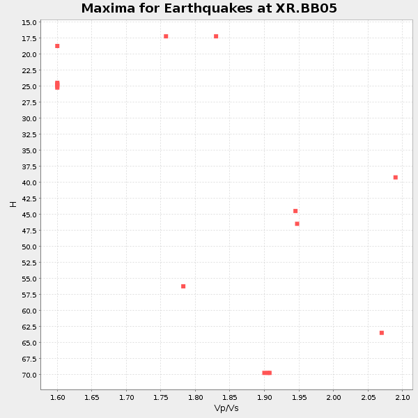
Plot maxima for each earthquake.
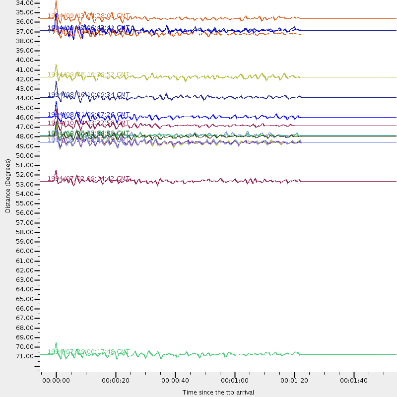
Events Used in the Stack
(16 events)| Radial Match | Distance | Baz | FERegion | Time | Lat/Lon | Depth | Magnitude |
| 95.53516 | 46.1 deg | 56.946 deg | Kuril Islands | 1994/10/04 13:22:58 GMT | (43.7, 147.3) | 33 km | 7.4 MB, 8.1 MS, 8.3 UNKNOWN, 8.2 MW |
| 92.4147 | 48.1 deg | 55.493 deg | East Of Kuril Islands | 1994/08/14 00:46:22 GMT | (44.7, 150.1) | 33 km | 5.9 MB, 5.8 MS, 5.4 UNKNOWN, 6.1 MW |
| 90.72066 | 35.5 deg | 58.678 deg | Primor'ye, Russia | 1994/07/21 18:36:31 GMT | (42.3, 132.9) | 473 km | 6.4 MB, 7.2 UNKNOWN |
| 90.27904 | 35.1 deg | 111.643 deg | Luzon, Philippines | 1994/06/09 16:22:22 GMT | (13.3, 124.2) | 80 km | 5.8 MB, 6.2 UNKNOWN |
| 89.98888 | 47.4 deg | 55.525 deg | Kuril Islands | 1994/08/20 04:38:51 GMT | (44.7, 149.1) | 33 km | 6.1 MB, 6.0 MS, 5.7 UNKNOWN, 6.3 MW |
| 89.28143 | 48.1 deg | 55.467 deg | East Of Kuril Islands | 1994/08/18 04:42:59 GMT | (44.7, 150.2) | 33 km | 6.1 MB, 6.5 MS, 6.6 UNKNOWN, 6.5 MW |
| 89.1742 | 35.1 deg | 110.705 deg | Luzon, Philippines | 1994/10/12 06:43:41 GMT | (13.7, 124.5) | 33 km | 5.8 MB, 6.1 MS, 6.9 UNKNOWN, 6.5 MW |
| 88.75293 | 47.3 deg | 124.844 deg | Halmahera, Indonesia | 1994/10/08 21:44:09 GMT | (-1.2, 128.0) | 31 km | 6.3 MB, 6.8 MS, 6.8 UNKNOWN, 6.9 MW |
| 87.115524 | 45.2 deg | 57.013 deg | Hokkaido, Japan Region | 1994/08/31 09:07:26 GMT | (43.7, 146.0) | 80 km | 5.9 MB, 6.2 UNKNOWN, 6.2 MW |
| 86.22391 | 48.1 deg | 55.42 deg | East Of Kuril Islands | 1994/08/28 18:37:19 GMT | (44.7, 150.2) | 14 km | 6.0 MB, 6.5 MS, 6.3 UNKNOWN, 6.7 MW |
| 85.949684 | 42.9 deg | 65.702 deg | Off East Coast Of Honshu, Japan | 1994/08/16 10:09:34 GMT | (37.8, 142.5) | 34 km | 5.8 MB, 5.2 MS, 5.1 UNKNOWN, 5.8 MW |
| 85.44006 | 33.7 deg | 81.885 deg | Ryukyu Islands, Japan | 1994/09/13 04:28:01 GMT | (29.3, 129.9) | 37 km | 5.8 MB, 6.3 MS, 6.2 UNKNOWN, 6.1 MW |
| 85.43683 | 72.6 deg | 39.103 deg | Fox Islands, Aleutian Islands | 1994/07/29 00:17:48 GMT | (52.4, -168.3) | 33 km | 5.9 MB, 5.6 MS, 5.8 UNKNOWN, 5.6 ML |
| 83.070206 | 40.5 deg | 149.364 deg | Java Sea | 1994/09/28 16:39:52 GMT | (-5.8, 110.3) | 643 km | 5.7 MB, 6.7 UNKNOWN, 6.6 MW |
| 82.55911 | 52.6 deg | 126.151 deg | Banda Sea | 1994/07/02 09:14:42 GMT | (-5.7, 131.0) | 78 km | 5.8 MB |
| 80.50152 | 47.2 deg | 124.91 deg | Halmahera, Indonesia | 1994/10/13 05:04:28 GMT | (-1.2, 127.9) | 33 km | 6.0 MB, 6.4 MS, 6.5 UNKNOWN, 6.4 MW |
Losers
(0 events)| Radial Match | Distance | Baz | FERegion | Time | Lat/Lon | Depth | Magnitude | Reason |
