You are here: Home > Network List > XR94 - INDEPTH II Stations List
> Station BB05 Ningchung > Earthquake Result Viewer
BB05 Ningchung - Earthquake Result Viewer
| Earthquake location: |
Kuril Islands |
| Earthquake latitude/longitude: |
43.7/147.3 |
| Earthquake time(UTC): |
1994/10/04 (277) 13:22:58 GMT |
| Earthquake Depth: |
33 km |
| Earthquake Magnitude: |
7.4 MB, 8.1 MS, 8.3 UNKNOWN, 8.2 MW |
| Earthquake Catalog/Contributor: |
WHDF/NEIC |
|
| Network: |
XR INDEPTH II |
| Station: |
BB05 Ningchung |
| Lat/Lon: |
30.38 N/90.91 E |
| Elevation: |
4219 m |
|
| Distance: |
46.1 deg |
| Az: |
272.847 deg |
| Baz: |
56.946 deg |
| Ray Param: |
0.07077672 |
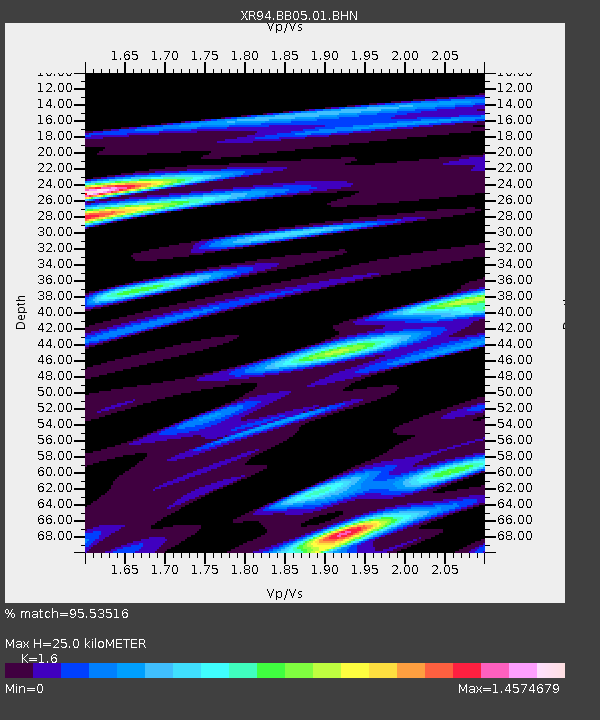
| Estimated Moho Depth: |
25.0 km |
| Estimated Crust Vp/Vs: |
1.60 |
| Assumed Crust Vp: |
6.5 km/s |
| Estimated Crust Vs: |
4.062 km/s |
| Estimated Crust Poisson's Ratio: |
0.18 |
|
| Radial Match: |
95.53516 % |
| Radial Bump: |
400 |
| Transverse Match: |
85.969025 % |
| Transverse Bump: |
400 |
| SOD ConfigId: |
17000 |
| Insert Time: |
2010-03-09 08:04:45.576 +0000 |
| GWidth: |
2.5 |
| Max Bumps: |
400 |
| Tol: |
0.001 |
|

Signal To Noise
| Channel | StoN | STA | LTA |
| XR:BB05:01:BHN:19941004T13:30:48.87901Z | 4.203923 | 1.3555027E-6 | 3.2243756E-7 |
| XR:BB05:01:BHE:19941004T13:30:48.87901Z | 4.521966 | 1.974496E-6 | 4.3664542E-7 |
| XR:BB05:01:BHZ:19941004T13:30:48.87901Z | 2.5172167 | 4.0146933E-6 | 1.5948938E-6 |
| Arrivals |
| Ps | 2.5 SECOND |
| PpPs | 9.3 SECOND |
| PsPs/PpSs | 12 SECOND |


