You are here: Home > Network List > XR94 - INDEPTH II Stations List
> Station BB05 Ningchung > Earthquake Result Viewer
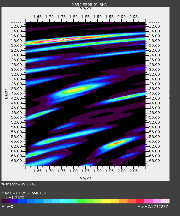
BB05 Ningchung - Earthquake Result Viewer
| Earthquake location: |
Luzon, Philippines |
| Earthquake latitude/longitude: |
13.7/124.5 |
| Earthquake time(UTC): |
1994/10/12 (285) 06:43:41 GMT |
| Earthquake Depth: |
33 km |
| Earthquake Magnitude: |
5.8 MB, 6.1 MS, 6.9 UNKNOWN, 6.5 MW |
| Earthquake Catalog/Contributor: |
WHDF/NEIC |
|
| Network: |
XR INDEPTH II |
| Station: |
BB05 Ningchung |
| Lat/Lon: |
30.38 N/90.91 E |
| Elevation: |
4219 m |
|
| Distance: |
35.1 deg |
| Az: |
303.71 deg |
| Baz: |
110.705 deg |
| Ray Param: |
0.07733899 |
| Estimated Moho Depth: |
17.25 km |
| Estimated Crust Vp/Vs: |
1.76 |
| Assumed Crust Vp: |
6.5 km/s |
| Estimated Crust Vs: |
3.698 km/s |
| Estimated Crust Poisson's Ratio: |
0.26 |
|
| Radial Match: |
89.1742 % |
| Radial Bump: |
400 |
| Transverse Match: |
78.63564 % |
| Transverse Bump: |
400 |
| SOD ConfigId: |
17000 |
| Insert Time: |
2010-03-09 08:04:49.509 +0000 |
| GWidth: |
2.5 |
| Max Bumps: |
400 |
| Tol: |
0.001 |
|

Signal To Noise
| Channel | StoN | STA | LTA |
| XR:BB05:01:BHN:19941012T06:50:01.61601Z | 0.44213483 | 9.282403E-8 | 2.0994509E-7 |
| XR:BB05:01:BHE:19941012T06:50:01.61601Z | 1.2996793 | 2.5673629E-7 | 1.9753818E-7 |
| XR:BB05:01:BHZ:19941012T06:50:01.61601Z | 1.1133982 | 2.2531084E-7 | 2.0236322E-7 |
| Arrivals |
| Ps | 2.2 SECOND |
| PpPs | 6.8 SECOND |
| PsPs/PpSs | 8.9 SECOND |


