You are here: Home > Network List > XR94 - INDEPTH II Stations List
> Station BB10 Shoba > Earthquake Result Viewer
BB10 Shoba - Earthquake Result Viewer
| Earthquake location: |
Banda Sea |
| Earthquake latitude/longitude: |
-7.4/128.1 |
| Earthquake time(UTC): |
1994/06/16 (167) 10:12:48 GMT |
| Earthquake Depth: |
119 km |
| Earthquake Magnitude: |
5.8 MB, 6.0 UNKNOWN, 5.9 MW |
| Earthquake Catalog/Contributor: |
WHDF/NEIC |
|
| Network: |
XR INDEPTH II |
| Station: |
BB10 Shoba |
| Lat/Lon: |
30.00 N/90.41 E |
| Elevation: |
4369 m |
|
| Distance: |
51.9 deg |
| Az: |
317.591 deg |
| Baz: |
129.549 deg |
| Ray Param: |
0.06673325 |
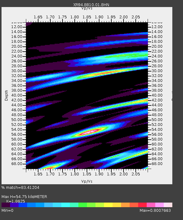
| Estimated Moho Depth: |
54.75 km |
| Estimated Crust Vp/Vs: |
1.86 |
| Assumed Crust Vp: |
6.514 km/s |
| Estimated Crust Vs: |
3.498 km/s |
| Estimated Crust Poisson's Ratio: |
0.30 |
|
| Radial Match: |
83.41204 % |
| Radial Bump: |
400 |
| Transverse Match: |
77.87299 % |
| Transverse Bump: |
400 |
| SOD ConfigId: |
16938 |
| Insert Time: |
2010-03-09 08:05:23.061 +0000 |
| GWidth: |
2.5 |
| Max Bumps: |
400 |
| Tol: |
0.001 |
|

Signal To Noise
| Channel | StoN | STA | LTA |
| XR:BB10:01:BHN:19940616T10:21:14.165985Z | 0.9817373 | 7.05692E-8 | 7.1881956E-8 |
| XR:BB10:01:BHE:19940616T10:21:14.165985Z | 1.649594 | 9.879033E-8 | 5.988767E-8 |
| XR:BB10:01:BHZ:19940616T10:21:14.165985Z | 3.521681 | 2.0520102E-7 | 5.8267915E-8 |
| Arrivals |
| Ps | 7.7 SECOND |
| PpPs | 23 SECOND |
| PsPs/PpSs | 30 SECOND |


