
Station XR BB10 - Shoba
Network: XR94 - INDEPTH II
Nearby stations (2 deg radius)

| Station | Name | (Lat, Lon) | Start / End | Elevation |
| BB10 | Shoba | (30.00, 90.41) | 1994-06-02 / 1994-12-31 | 4369 m |
| Crust2 Type: | RD,orogen/70km Tibet, no seds. |
| Thickness Estimate: | 32 km |
| Thickness StdDev: | 6.9 km |
| Vp/Vs Estimate: | 1.79 |
| Vp/Vs StdDev: | 0.12 |
| Vs Estimate: | 3.644 km/s |
| Poisson's Ratio: | 0.27 |
| Peak Value: | 0.03 |
| Assumed Vp: | 6.514 km/s |
| Ps Weight: | 0.33333334 |
| PpPs Weight: | 0.33333334 |
| PsPs Weight: | 0.33333328 |
| Residual Complexity: | 0.716 |
| Nearby stations H: | +- |
| (2.0 deg) Vp/Vs: | +- |
7 with match > 90% ( 31.818182 %) and 22 with match > 80% ( 100.0 %) out of 22.
Download stack as xyz text file.
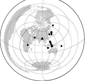
Azimuth Distribution of Events:
Prior Results for this Station
| Study | Thickness | Vp/Vs | Vp | Vs | Poissons Ratio | Extra |
| EARS | 32 km | 1.79 | 6.514 km/s | 3.644 km/s | 0.27 | |
| Crust2.0 | 70 km | 1.76 | 6.514 km/s | 3.706 km/s | 0.26 | RD,orogen/70km Tibet, no seds. |
| Global Maxima | 32 km | 1.79 | 6.514 km/s | 3.644 km/s | 0.27 | amp=0.025048919 |
| Local Maxima 1 | 43 km | 1.60 | 6.514 km/s | 4.071 km/s | 0.18 | amp=0.02268234 |
| Local Maxima 2 | 25 km | 1.94 | 6.514 km/s | 3.362 km/s | 0.32 | amp=0.020740917 |
| Local Maxima 3 | 50 km | 1.93 | 6.514 km/s | 3.371 km/s | 0.32 | amp=0.020505104 |
| Local Maxima 4 | 36 km | 1.67 | 6.514 km/s | 3.895 km/s | 0.22 | amp=0.018472848 |
| Predicted Arrivals for vertical incidence (zero ray parameter) | |
| Ps | 3.90 SECOND |
| PpPs | 13.80 SECOND |
| PsPs/PpSs | 17.70 SECOND |
Events Processed for this Station
Download zip of receiver functions as SAC
Plot maxima for each earthquake.
Events Used in the Stack
(22 events)| Radial Match | Distance | Baz | FERegion | Time | Lat/Lon | Depth | Magnitude |
| 93.68673 | 46.7 deg | 56.619 deg | Kuril Islands | 1994/10/04 13:22:58 GMT | (43.7, 147.3) | 33 km | 7.4 MB, 8.1 MS, 8.3 UNKNOWN, 8.2 MW |
| 93.4422 | 45.7 deg | 148.194 deg | South Of Java, Indonesia | 1994/06/02 18:17:36 GMT | (-10.5, 113.0) | 39 km | 5.5 MB, 7.2 MS, 6.8 UNKNOWN, 7.7 MW |
| 91.59686 | 47.4 deg | 124.082 deg | Halmahera, Indonesia | 1994/10/08 21:44:09 GMT | (-1.2, 128.0) | 31 km | 6.3 MB, 6.8 MS, 6.8 UNKNOWN, 6.9 MW |
| 91.5383 | 48.0 deg | 53.777 deg | Kuril Islands | 1994/10/16 05:10:03 GMT | (45.7, 149.2) | 139 km | 6.3 MB, 6.8 UNKNOWN, 6.7 MW |
| 90.81307 | 48.7 deg | 55.158 deg | East Of Kuril Islands | 1994/08/18 04:42:59 GMT | (44.7, 150.2) | 33 km | 6.1 MB, 6.5 MS, 6.6 UNKNOWN, 6.5 MW |
| 90.37259 | 35.4 deg | 109.716 deg | Luzon, Philippines | 1994/10/12 06:02:50 GMT | (13.7, 124.5) | 33 km | 5.4 MB, 5.7 MS, 5.6 UNKNOWN |
| 90.04579 | 46.2 deg | 147.852 deg | South Of Java, Indonesia | 1994/06/04 00:57:53 GMT | (-10.8, 113.4) | 33 km | 5.8 MB, 6.2 MS, 6.0 UNKNOWN |
| 89.46171 | 45.9 deg | 147.474 deg | South Of Java, Indonesia | 1994/06/15 09:22:57 GMT | (-10.4, 113.5) | 33 km | 5.8 MB, 6.1 MS, 5.9 UNKNOWN, 6.0 MW |
| 89.15178 | 35.4 deg | 110.674 deg | Luzon, Philippines | 1994/06/09 16:22:22 GMT | (13.3, 124.2) | 80 km | 5.8 MB, 6.2 UNKNOWN |
| 88.91891 | 53.5 deg | 125.567 deg | Tanimbar Islands Reg., Indonesia | 1994/08/04 22:15:37 GMT | (-6.3, 131.5) | 33 km | 6.1 MB, 5.6 MS, 6.1 UNKNOWN |
| 88.6052 | 67.4 deg | 246.568 deg | Lake Tanganyika Region | 1994/08/18 00:45:48 GMT | (-7.3, 31.8) | 29 km | 6.0 MB, 5.8 MS, 6.1 UNKNOWN, 5.9 MW |
| 88.54385 | 47.4 deg | 124.148 deg | Halmahera, Indonesia | 1994/10/13 05:04:28 GMT | (-1.2, 127.9) | 33 km | 6.0 MB, 6.4 MS, 6.5 UNKNOWN, 6.4 MW |
| 88.47573 | 45.7 deg | 56.682 deg | Hokkaido, Japan Region | 1994/08/31 09:07:26 GMT | (43.7, 146.0) | 80 km | 5.9 MB, 6.2 UNKNOWN, 6.2 MW |
| 88.16922 | 36.1 deg | 58.291 deg | Primor'ye, Russia | 1994/07/21 18:36:31 GMT | (42.3, 132.9) | 473 km | 6.4 MB, 7.2 UNKNOWN |
| 87.63384 | 41.1 deg | 118.456 deg | Mindanao, Philippines | 1994/07/06 09:13:11 GMT | (6.0, 125.9) | 164 km | 5.7 MB, 6.1 UNKNOWN |
| 86.66686 | 37.9 deg | 113.627 deg | Leyte, Philippines | 1994/07/05 10:09:22 GMT | (10.4, 125.3) | 30 km | 5.4 MB, 5.5 MS |
| 85.447975 | 43.4 deg | 65.275 deg | Off East Coast Of Honshu, Japan | 1994/08/16 10:09:34 GMT | (37.8, 142.5) | 34 km | 5.8 MB, 5.2 MS, 5.1 UNKNOWN, 5.8 MW |
| 83.626274 | 87.5 deg | 110.703 deg | Vanuatu Islands | 1994/07/13 02:35:55 GMT | (-16.6, 167.5) | 33 km | 6.3 MB, 7.4 MS, 7.3 UNKNOWN, 7.1 MW |
| 83.41204 | 51.9 deg | 129.549 deg | Banda Sea | 1994/06/16 10:12:48 GMT | (-7.4, 128.1) | 119 km | 5.8 MB, 6.0 UNKNOWN, 5.9 MW |
| 82.710045 | 45.7 deg | 148.329 deg | South Of Java, Indonesia | 1994/06/03 21:06:57 GMT | (-10.5, 112.9) | 16 km | 5.9 MB, 6.4 MS, 6.3 UNKNOWN, 6.6 MW |
| 82.391914 | 73.2 deg | 38.884 deg | Fox Islands, Aleutian Islands | 1994/07/29 00:17:48 GMT | (52.4, -168.3) | 33 km | 5.9 MB, 5.6 MS, 5.8 UNKNOWN, 5.6 ML |
| 81.84991 | 32.9 deg | 277.669 deg | Southern Iran | 1994/06/20 09:09:04 GMT | (28.9, 52.6) | 17 km | 5.9 MB, 5.7 MS, 5.9 UNKNOWN, 5.8 MD |
Losers
(0 events)| Radial Match | Distance | Baz | FERegion | Time | Lat/Lon | Depth | Magnitude | Reason |
