You are here: Home > Network List > XR94 - INDEPTH II Stations List
> Station BB14 Noga > Earthquake Result Viewer
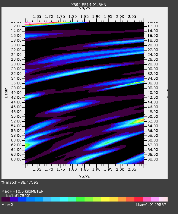
BB14 Noga - Earthquake Result Viewer
| Earthquake location: |
Luzon, Philippines |
| Earthquake latitude/longitude: |
13.3/124.2 |
| Earthquake time(UTC): |
1994/06/09 (160) 16:22:22 GMT |
| Earthquake Depth: |
80 km |
| Earthquake Magnitude: |
5.8 MB, 6.2 UNKNOWN |
| Earthquake Catalog/Contributor: |
WHDF/NEIC |
|
| Network: |
XR INDEPTH II |
| Station: |
BB14 Noga |
| Lat/Lon: |
29.37 N/90.18 E |
| Elevation: |
3793 m |
|
| Distance: |
35.4 deg |
| Az: |
302.395 deg |
| Baz: |
109.635 deg |
| Ray Param: |
0.0770131 |
| Estimated Moho Depth: |
10.5 km |
| Estimated Crust Vp/Vs: |
1.62 |
| Assumed Crust Vp: |
6.514 km/s |
| Estimated Crust Vs: |
4.027 km/s |
| Estimated Crust Poisson's Ratio: |
0.19 |
|
| Radial Match: |
86.47593 % |
| Radial Bump: |
400 |
| Transverse Match: |
86.493546 % |
| Transverse Bump: |
400 |
| SOD ConfigId: |
16938 |
| Insert Time: |
2010-03-09 08:05:53.689 +0000 |
| GWidth: |
2.5 |
| Max Bumps: |
400 |
| Tol: |
0.001 |
|

Signal To Noise
| Channel | StoN | STA | LTA |
| XR:BB14:01:BHN:19940609T16:28:40.244989Z | 1.2788612 | 1.29307125E-8 | 1.0111115E-8 |
| XR:BB14:01:BHE:19940609T16:28:40.244989Z | 10.336495 | 5.675662E-7 | 5.4908952E-8 |
| XR:BB14:01:BHZ:19940609T16:28:40.244989Z | 21.91317 | 1.2724807E-6 | 5.8069222E-8 |
| Arrivals |
| Ps | 1.1 SECOND |
| PpPs | 3.9 SECOND |
| PsPs/PpSs | 5.0 SECOND |


