
Station XR BB14 - Noga
Network: XR94 - INDEPTH II
Nearby stations (2 deg radius)
| Station | Name | (Lat, Lon) | Start / End | Elevation |
| BB14 | Noga | (29.37, 90.18) | 1994-05-28 / 1994-12-31 | 3793 m |
| Crust2 Type: | RD,orogen/70km Tibet, no seds. |
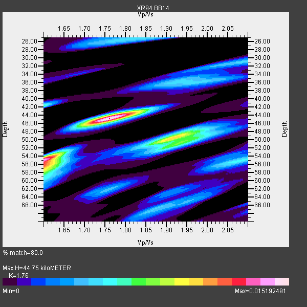
| Thickness Estimate: | 45 km |
| Thickness StdDev: | 5.6 km |
| Vp/Vs Estimate: | 1.76 |
| Vp/Vs StdDev: | 0.11 |
| Vs Estimate: | 3.701 km/s |
| Poisson's Ratio: | 0.26 |
| Peak Value: | 0.02 |
| Assumed Vp: | 6.514 km/s |
| Ps Weight: | 0.33333334 |
| PpPs Weight: | 0.33333334 |
| PsPs Weight: | 0.33333328 |
| Residual Complexity: | 0.782 |
| Nearby stations H: | +- |
| (2.0 deg) Vp/Vs: | +- |
6 with match > 90% ( 33.333332 %) and 18 with match > 80% ( 100.0 %) out of 18.
Download stack as xyz text file.
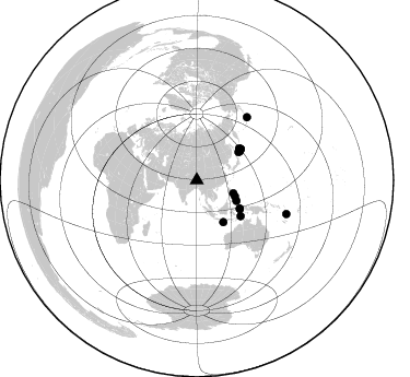
Azimuth Distribution of Events:
Prior Results for this Station
| Study | Thickness | Vp/Vs | Vp | Vs | Poissons Ratio | Extra |
| EARS | 45 km | 1.76 | 6.514 km/s | 3.701 km/s | 0.26 | |
| Crust2.0 | 70 km | 1.76 | 6.514 km/s | 3.706 km/s | 0.26 | RD,orogen/70km Tibet, no seds. |
| Global Maxima | 45 km | 1.76 | 6.514 km/s | 3.701 km/s | 0.26 | amp=0.015192491 |
| Local Maxima 1 | 55 km | 1.60 | 6.514 km/s | 4.071 km/s | 0.18 | amp=0.0124123385 |
| Local Maxima 2 | 50 km | 1.90 | 6.514 km/s | 3.424 km/s | 0.31 | amp=0.008679281 |
| Local Maxima 3 | 57 km | 1.60 | 6.514 km/s | 4.071 km/s | 0.18 | amp=0.006908496 |
| Local Maxima 4 | 42 km | 1.60 | 6.514 km/s | 4.071 km/s | 0.18 | amp=0.0067389123 |
| Predicted Arrivals for vertical incidence (zero ray parameter) | |
| Ps | 5.22 SECOND |
| PpPs | 18.96 SECOND |
| PsPs/PpSs | 24.18 SECOND |
Events Processed for this Station
Download zip of receiver functions as SAC
Plot maxima for each earthquake.
Events Used in the Stack
(18 events)| Radial Match | Distance | Baz | FERegion | Time | Lat/Lon | Depth | Magnitude |
| 96.86124 | 47.6 deg | 55.837 deg | Kuril Islands | 1994/10/09 07:55:38 GMT | (43.9, 147.9) | 23 km | 6.5 MB, 7.0 MS, 6.7 UNKNOWN, 7.3 MW |
| 95.272835 | 47.2 deg | 56.121 deg | Kuril Islands | 1994/10/04 13:22:58 GMT | (43.7, 147.3) | 33 km | 7.4 MB, 8.1 MS, 8.3 UNKNOWN, 8.2 MW |
| 95.18628 | 45.3 deg | 147.587 deg | South Of Java, Indonesia | 1994/06/02 18:17:36 GMT | (-10.5, 113.0) | 39 km | 5.5 MB, 7.2 MS, 6.8 UNKNOWN, 7.7 MW |
| 95.012115 | 49.2 deg | 54.652 deg | East Of Kuril Islands | 1994/08/28 18:37:19 GMT | (44.7, 150.2) | 14 km | 6.0 MB, 6.5 MS, 6.3 UNKNOWN, 6.7 MW |
| 94.75563 | 48.5 deg | 54.744 deg | Kuril Islands | 1994/08/20 04:38:51 GMT | (44.7, 149.1) | 33 km | 6.1 MB, 6.0 MS, 5.7 UNKNOWN, 6.3 MW |
| 90.95291 | 49.2 deg | 54.723 deg | East Of Kuril Islands | 1994/08/14 00:46:22 GMT | (44.7, 150.1) | 33 km | 5.9 MB, 5.8 MS, 5.4 UNKNOWN, 6.1 MW |
| 89.26241 | 46.2 deg | 56.171 deg | Hokkaido, Japan Region | 1994/08/31 09:07:26 GMT | (43.7, 146.0) | 80 km | 5.9 MB, 6.2 UNKNOWN, 6.2 MW |
| 89.02084 | 47.2 deg | 123.386 deg | Halmahera, Indonesia | 1994/10/08 21:44:09 GMT | (-1.2, 128.0) | 31 km | 6.3 MB, 6.8 MS, 6.8 UNKNOWN, 6.9 MW |
| 88.38746 | 49.2 deg | 54.698 deg | East Of Kuril Islands | 1994/08/18 04:42:59 GMT | (44.7, 150.2) | 33 km | 6.1 MB, 6.5 MS, 6.6 UNKNOWN, 6.5 MW |
| 87.8428 | 48.5 deg | 53.319 deg | Kuril Islands | 1994/10/16 05:10:03 GMT | (45.7, 149.2) | 139 km | 6.3 MB, 6.8 UNKNOWN, 6.7 MW |
| 86.66748 | 87.4 deg | 110.561 deg | Vanuatu Islands | 1994/07/13 02:35:55 GMT | (-16.6, 167.5) | 33 km | 6.3 MB, 7.4 MS, 7.3 UNKNOWN, 7.1 MW |
| 86.622765 | 41.0 deg | 117.599 deg | Mindanao, Philippines | 1994/07/06 09:13:11 GMT | (6.0, 125.9) | 164 km | 5.7 MB, 6.1 UNKNOWN |
| 86.53888 | 47.6 deg | 55.792 deg | Kuril Islands | 1994/10/04 13:52:46 GMT | (43.9, 147.8) | 33 km | 5.9 MB |
| 86.47593 | 35.4 deg | 109.635 deg | Luzon, Philippines | 1994/06/09 16:22:22 GMT | (13.3, 124.2) | 80 km | 5.8 MB, 6.2 UNKNOWN |
| 83.399216 | 51.6 deg | 129.243 deg | Banda Sea | 1994/07/13 11:45:25 GMT | (-7.5, 127.9) | 185 km | 6.4 MB, 6.8 UNKNOWN, 6.5 MW |
| 82.85852 | 73.8 deg | 38.7 deg | Fox Islands, Aleutian Islands | 1994/07/29 00:17:48 GMT | (52.4, -168.3) | 33 km | 5.9 MB, 5.6 MS, 5.8 UNKNOWN, 5.6 ML |
| 82.59287 | 47.2 deg | 123.452 deg | Halmahera, Indonesia | 1994/10/13 05:04:28 GMT | (-1.2, 127.9) | 33 km | 6.0 MB, 6.4 MS, 6.5 UNKNOWN, 6.4 MW |
| 81.10803 | 37.8 deg | 112.671 deg | Leyte, Philippines | 1994/07/05 10:09:22 GMT | (10.4, 125.3) | 30 km | 5.4 MB, 5.5 MS |
Losers
(0 events)| Radial Match | Distance | Baz | FERegion | Time | Lat/Lon | Depth | Magnitude | Reason |
