You are here: Home > Network List > XR94 - INDEPTH II Stations List
> Station BB14 Noga > Earthquake Result Viewer
BB14 Noga - Earthquake Result Viewer
| Earthquake location: |
Mindanao, Philippines |
| Earthquake latitude/longitude: |
6.0/125.9 |
| Earthquake time(UTC): |
1994/07/06 (187) 09:13:11 GMT |
| Earthquake Depth: |
164 km |
| Earthquake Magnitude: |
5.7 MB, 6.1 UNKNOWN |
| Earthquake Catalog/Contributor: |
WHDF/NEIC |
|
| Network: |
XR INDEPTH II |
| Station: |
BB14 Noga |
| Lat/Lon: |
29.37 N/90.18 E |
| Elevation: |
3793 m |
|
| Distance: |
41.0 deg |
| Az: |
308.947 deg |
| Baz: |
117.599 deg |
| Ray Param: |
0.07345328 |
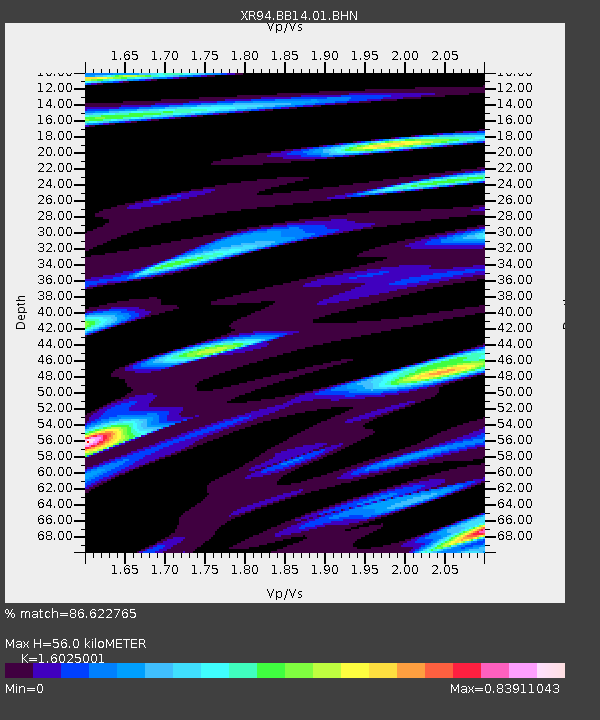
| Estimated Moho Depth: |
56.0 km |
| Estimated Crust Vp/Vs: |
1.60 |
| Assumed Crust Vp: |
6.514 km/s |
| Estimated Crust Vs: |
4.065 km/s |
| Estimated Crust Poisson's Ratio: |
0.18 |
|
| Radial Match: |
86.622765 % |
| Radial Bump: |
400 |
| Transverse Match: |
85.160675 % |
| Transverse Bump: |
400 |
| SOD ConfigId: |
16938 |
| Insert Time: |
2010-03-09 08:05:55.157 +0000 |
| GWidth: |
2.5 |
| Max Bumps: |
400 |
| Tol: |
0.001 |
|

Signal To Noise
| Channel | StoN | STA | LTA |
| XR:BB14:01:BHN:19940706T09:20:07.457013Z | 1.7107286 | 5.813792E-8 | 3.3984303E-8 |
| XR:BB14:01:BHE:19940706T09:20:07.457013Z | 2.5277348 | 1.4065785E-7 | 5.564581E-8 |
| XR:BB14:01:BHZ:19940706T09:20:07.457013Z | 4.8404837 | 2.7098355E-7 | 5.598274E-8 |
| Arrivals |
| Ps | 5.6 SECOND |
| PpPs | 21 SECOND |
| PsPs/PpSs | 26 SECOND |


