You are here: Home > Network List > XR94 - INDEPTH II Stations List
> Station BB14 Noga > Earthquake Result Viewer
BB14 Noga - Earthquake Result Viewer
| Earthquake location: |
Banda Sea |
| Earthquake latitude/longitude: |
-7.5/127.9 |
| Earthquake time(UTC): |
1994/07/13 (194) 11:45:25 GMT |
| Earthquake Depth: |
185 km |
| Earthquake Magnitude: |
6.4 MB, 6.8 UNKNOWN, 6.5 MW |
| Earthquake Catalog/Contributor: |
WHDF/NEIC |
|
| Network: |
XR INDEPTH II |
| Station: |
BB14 Noga |
| Lat/Lon: |
29.37 N/90.18 E |
| Elevation: |
3793 m |
|
| Distance: |
51.6 deg |
| Az: |
317.017 deg |
| Baz: |
129.243 deg |
| Ray Param: |
0.06665725 |
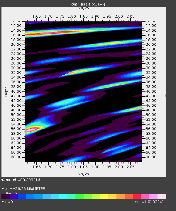
| Estimated Moho Depth: |
56.25 km |
| Estimated Crust Vp/Vs: |
1.62 |
| Assumed Crust Vp: |
6.514 km/s |
| Estimated Crust Vs: |
4.021 km/s |
| Estimated Crust Poisson's Ratio: |
0.19 |
|
| Radial Match: |
83.399216 % |
| Radial Bump: |
400 |
| Transverse Match: |
88.829124 % |
| Transverse Bump: |
391 |
| SOD ConfigId: |
16938 |
| Insert Time: |
2010-03-09 08:05:58.319 +0000 |
| GWidth: |
2.5 |
| Max Bumps: |
400 |
| Tol: |
0.001 |
|

Signal To Noise
| Channel | StoN | STA | LTA |
| XR:BB14:01:BHN:19940713T11:53:42.578009Z | 9.344609 | 5.679885E-7 | 6.0782476E-8 |
| XR:BB14:01:BHE:19940713T11:53:42.578009Z | 18.03451 | 1.2801488E-6 | 7.098329E-8 |
| XR:BB14:01:BHZ:19940713T11:53:42.578009Z | 65.50131 | 5.318239E-6 | 8.1192866E-8 |
| Arrivals |
| Ps | 5.7 SECOND |
| PpPs | 21 SECOND |
| PsPs/PpSs | 27 SECOND |


