You are here: Home > Network List > XR94 - INDEPTH II Stations List
> Station BB14 Noga > Earthquake Result Viewer
BB14 Noga - Earthquake Result Viewer
| Earthquake location: |
Hokkaido, Japan Region |
| Earthquake latitude/longitude: |
43.7/146.0 |
| Earthquake time(UTC): |
1994/08/31 (243) 09:07:26 GMT |
| Earthquake Depth: |
80 km |
| Earthquake Magnitude: |
5.9 MB, 6.2 UNKNOWN, 6.2 MW |
| Earthquake Catalog/Contributor: |
WHDF/NEIC |
|
| Network: |
XR INDEPTH II |
| Station: |
BB14 Noga |
| Lat/Lon: |
29.37 N/90.18 E |
| Elevation: |
3793 m |
|
| Distance: |
46.2 deg |
| Az: |
271.282 deg |
| Baz: |
56.171 deg |
| Ray Param: |
0.07052509 |
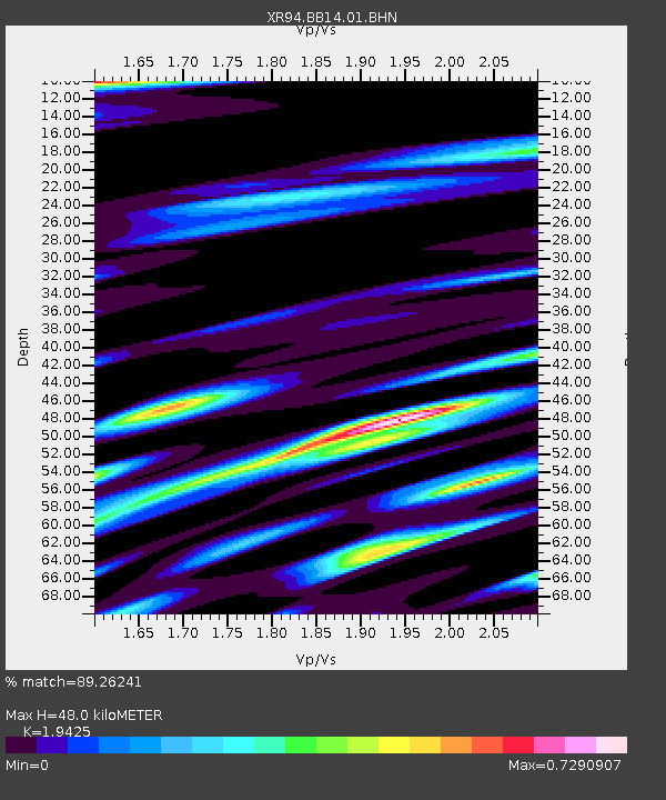
| Estimated Moho Depth: |
48.0 km |
| Estimated Crust Vp/Vs: |
1.94 |
| Assumed Crust Vp: |
6.514 km/s |
| Estimated Crust Vs: |
3.354 km/s |
| Estimated Crust Poisson's Ratio: |
0.32 |
|
| Radial Match: |
89.26241 % |
| Radial Bump: |
369 |
| Transverse Match: |
71.59662 % |
| Transverse Bump: |
400 |
| SOD ConfigId: |
17000 |
| Insert Time: |
2010-03-09 08:06:12.914 +0000 |
| GWidth: |
2.5 |
| Max Bumps: |
400 |
| Tol: |
0.001 |
|

Signal To Noise
| Channel | StoN | STA | LTA |
| XR:BB14:01:BHN:19940831T09:15:12.904987Z | 12.782253 | 5.664814E-7 | 4.43178E-8 |
| XR:BB14:01:BHE:19940831T09:15:12.904987Z | 15.272112 | 7.057474E-7 | 4.6211518E-8 |
| XR:BB14:01:BHZ:19940831T09:15:12.904987Z | 52.01196 | 2.1310084E-6 | 4.097151E-8 |
| Arrivals |
| Ps | 7.4 SECOND |
| PpPs | 20 SECOND |
| PsPs/PpSs | 28 SECOND |


