You are here: Home > Network List > XR94 - INDEPTH II Stations List
> Station BB14 Noga > Earthquake Result Viewer
BB14 Noga - Earthquake Result Viewer
| Earthquake location: |
Halmahera, Indonesia |
| Earthquake latitude/longitude: |
-1.2/127.9 |
| Earthquake time(UTC): |
1994/10/13 (286) 05:04:28 GMT |
| Earthquake Depth: |
33 km |
| Earthquake Magnitude: |
6.0 MB, 6.4 MS, 6.5 UNKNOWN, 6.4 MW |
| Earthquake Catalog/Contributor: |
WHDF/NEIC |
|
| Network: |
XR INDEPTH II |
| Station: |
BB14 Noga |
| Lat/Lon: |
29.37 N/90.18 E |
| Elevation: |
3793 m |
|
| Distance: |
47.2 deg |
| Az: |
313.242 deg |
| Baz: |
123.452 deg |
| Ray Param: |
0.0700775 |
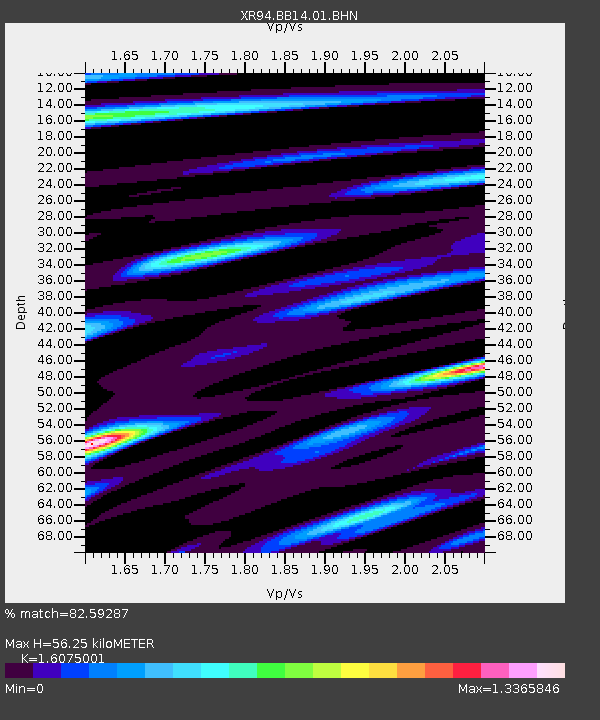
| Estimated Moho Depth: |
56.25 km |
| Estimated Crust Vp/Vs: |
1.61 |
| Assumed Crust Vp: |
6.514 km/s |
| Estimated Crust Vs: |
4.052 km/s |
| Estimated Crust Poisson's Ratio: |
0.18 |
|
| Radial Match: |
82.59287 % |
| Radial Bump: |
400 |
| Transverse Match: |
78.65595 % |
| Transverse Bump: |
400 |
| SOD ConfigId: |
17000 |
| Insert Time: |
2010-03-09 08:06:23.461 +0000 |
| GWidth: |
2.5 |
| Max Bumps: |
400 |
| Tol: |
0.001 |
|

Signal To Noise
| Channel | StoN | STA | LTA |
| XR:BB14:01:BHN:19941013T05:12:27.345013Z | 4.1560183 | 1.7027827E-7 | 4.0971493E-8 |
| XR:BB14:01:BHE:19941013T05:12:27.345013Z | 9.693982 | 4.4267355E-7 | 4.566478E-8 |
| XR:BB14:01:BHZ:19941013T05:12:27.345013Z | 23.237324 | 1.352411E-6 | 5.8199944E-8 |
| Arrivals |
| Ps | 5.6 SECOND |
| PpPs | 21 SECOND |
| PsPs/PpSs | 27 SECOND |


