You are here: Home > Network List > XR94 - INDEPTH II Stations List
> Station BB20 Nangpa > Earthquake Result Viewer
BB20 Nangpa - Earthquake Result Viewer
| Earthquake location: |
Luzon, Philippines |
| Earthquake latitude/longitude: |
13.7/124.5 |
| Earthquake time(UTC): |
1994/10/12 (285) 06:43:41 GMT |
| Earthquake Depth: |
33 km |
| Earthquake Magnitude: |
5.8 MB, 6.1 MS, 6.9 UNKNOWN, 6.5 MW |
| Earthquake Catalog/Contributor: |
WHDF/NEIC |
|
| Network: |
XR INDEPTH II |
| Station: |
BB20 Nangpa |
| Lat/Lon: |
28.73 N/89.66 E |
| Elevation: |
4245 m |
|
| Distance: |
35.6 deg |
| Az: |
300.408 deg |
| Baz: |
107.399 deg |
| Ray Param: |
0.077079125 |
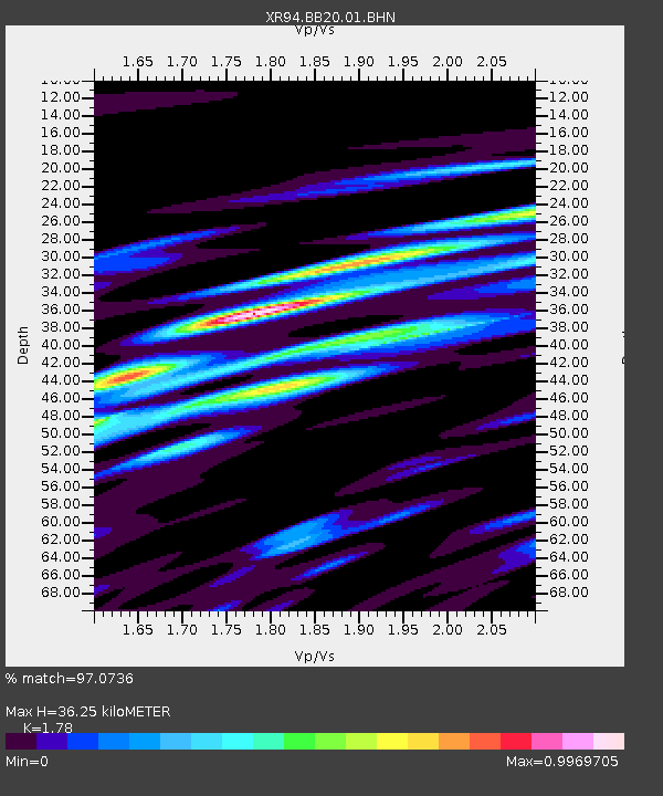
| Estimated Moho Depth: |
36.25 km |
| Estimated Crust Vp/Vs: |
1.78 |
| Assumed Crust Vp: |
6.514 km/s |
| Estimated Crust Vs: |
3.66 km/s |
| Estimated Crust Poisson's Ratio: |
0.27 |
|
| Radial Match: |
97.0736 % |
| Radial Bump: |
338 |
| Transverse Match: |
95.2554 % |
| Transverse Bump: |
400 |
| SOD ConfigId: |
17000 |
| Insert Time: |
2010-03-09 08:06:40.096 +0000 |
| GWidth: |
2.5 |
| Max Bumps: |
400 |
| Tol: |
0.001 |
|

Signal To Noise
| Channel | StoN | STA | LTA |
| XR:BB20:01:BHN:19941012T06:50:05.802014Z | 1.2228018 | 1.4375181E-9 | 1.1755937E-9 |
| XR:BB20:01:BHE:19941012T06:50:05.802014Z | 2.0437107 | 3.4775056E-9 | 1.7015643E-9 |
| XR:BB20:01:BHZ:19941012T06:50:05.802014Z | 6.047814 | 8.983702E-9 | 1.4854461E-9 |
| Arrivals |
| Ps | 4.7 SECOND |
| PpPs | 14 SECOND |
| PsPs/PpSs | 19 SECOND |


