
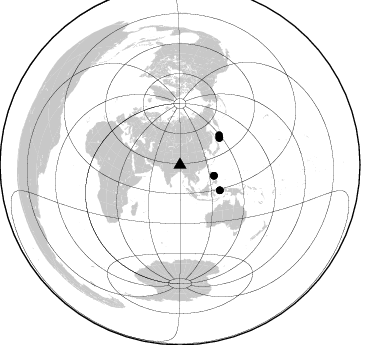
Station XR BB20 - Nangpa
Network: XR94 - INDEPTH II
Nearby stations (2 deg radius)

| Station | Name | (Lat, Lon) | Start / End | Elevation |
| BB20 | Nangpa | (28.73, 89.66) | 1994-05-31 / 1994-12-31 | 4245 m |
| Crust2 Type: | RD,orogen/70km Tibet, no seds. |
| Thickness Estimate: | 25 km |
| Thickness StdDev: | 9.1 km |
| Vp/Vs Estimate: | 1.66 |
| Vp/Vs StdDev: | 0.14 |
| Vs Estimate: | 3.918 km/s |
| Poisson's Ratio: | 0.22 |
| Peak Value: | 0.04 |
| Assumed Vp: | 6.514 km/s |
| Ps Weight: | 0.33333334 |
| PpPs Weight: | 0.33333334 |
| PsPs Weight: | 0.33333328 |
| Residual Complexity: | 0.904 |
| Nearby stations H: | +- |
| (2.0 deg) Vp/Vs: | +- |
4 with match > 90% ( 57.142857 %) and 7 with match > 80% ( 100.0 %) out of 7.
Download stack as xyz text file.
Azimuth Distribution of Events:
Prior Results for this Station
| Study | Thickness | Vp/Vs | Vp | Vs | Poissons Ratio | Extra |
| EARS | 25 km | 1.66 | 6.514 km/s | 3.918 km/s | 0.22 | |
| Crust2.0 | 70 km | 1.76 | 6.514 km/s | 3.706 km/s | 0.26 | RD,orogen/70km Tibet, no seds. |
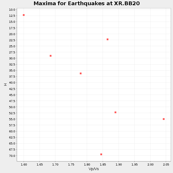
| Global Maxima | 25 km | 1.66 | 6.514 km/s | 3.918 km/s | 0.22 | amp=0.03749115 |
| Local Maxima 1 | 30 km | 1.63 | 6.514 km/s | 3.984 km/s | 0.20 | amp=0.02464463 |
| Local Maxima 2 | 40 km | 1.89 | 6.514 km/s | 3.442 km/s | 0.31 | amp=0.021427775 |
| Local Maxima 3 | 38 km | 1.74 | 6.514 km/s | 3.749 km/s | 0.25 | amp=0.018098686 |
| Local Maxima 4 | 30 km | 1.94 | 6.514 km/s | 3.358 km/s | 0.32 | amp=0.01658492 |
| Predicted Arrivals for vertical incidence (zero ray parameter) | |
| Ps | 2.54 SECOND |
| PpPs | 10.22 SECOND |
| PsPs/PpSs | 12.76 SECOND |
Events Processed for this Station
Download zip of receiver functions as SAC
Plot maxima for each earthquake.
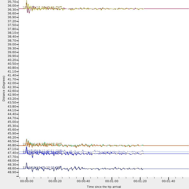
Events Used in the Stack
(7 events)| Radial Match | Distance | Baz | FERegion | Time | Lat/Lon | Depth | Magnitude |
| 97.194046 | 47.2 deg | 122.475 deg | Halmahera, Indonesia | 1994/10/13 05:04:28 GMT | (-1.2, 127.9) | 33 km | 6.0 MB, 6.4 MS, 6.5 UNKNOWN, 6.4 MW |
| 97.0736 | 35.6 deg | 107.399 deg | Luzon, Philippines | 1994/10/12 06:43:41 GMT | (13.7, 124.5) | 33 km | 5.8 MB, 6.1 MS, 6.9 UNKNOWN, 6.5 MW |
| 96.98591 | 35.6 deg | 107.377 deg | Luzon, Philippines | 1994/10/12 06:02:50 GMT | (13.7, 124.5) | 33 km | 5.4 MB, 5.7 MS, 5.6 UNKNOWN |
| 95.38866 | 47.3 deg | 122.41 deg | Halmahera, Indonesia | 1994/10/08 21:44:09 GMT | (-1.2, 128.0) | 31 km | 6.3 MB, 6.8 MS, 6.8 UNKNOWN, 6.9 MW |
| 88.38546 | 49.2 deg | 52.861 deg | Kuril Islands | 1994/10/16 05:10:03 GMT | (45.7, 149.2) | 139 km | 6.3 MB, 6.8 UNKNOWN, 6.7 MW |
| 83.03601 | 47.9 deg | 55.62 deg | Kuril Islands | 1994/10/04 13:22:58 GMT | (43.7, 147.3) | 33 km | 7.4 MB, 8.1 MS, 8.3 UNKNOWN, 8.2 MW |
| 81.383 | 47.8 deg | 55.833 deg | Kuril Islands | 1994/10/18 17:12:51 GMT | (43.6, 147.1) | 66 km | 6.1 MB, 6.1 UNKNOWN, 5.9 MW |
Losers
(0 events)| Radial Match | Distance | Baz | FERegion | Time | Lat/Lon | Depth | Magnitude | Reason |
