You are here: Home > Network List > XR94 - INDEPTH II Stations List
> Station BB23 Galon > Earthquake Result Viewer
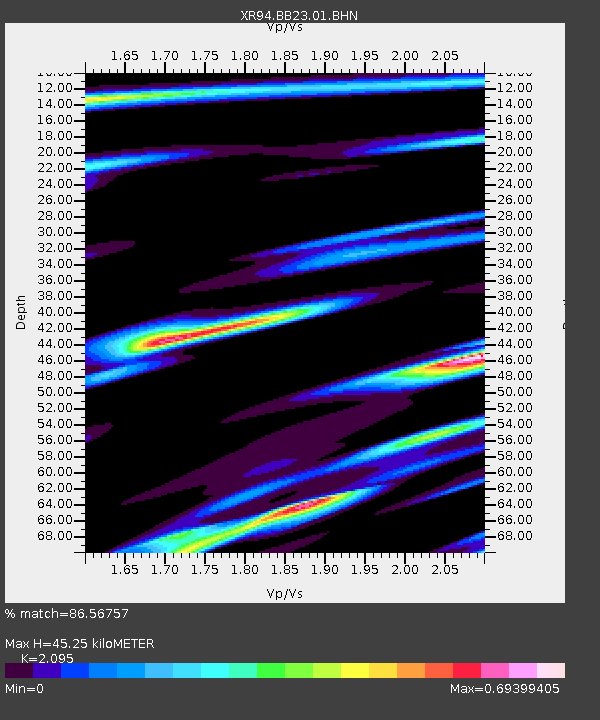
BB23 Galon - Earthquake Result Viewer
| Earthquake location: |
East Of Kuril Islands |
| Earthquake latitude/longitude: |
44.7/150.2 |
| Earthquake time(UTC): |
1994/08/18 (230) 04:42:59 GMT |
| Earthquake Depth: |
33 km |
| Earthquake Magnitude: |
6.1 MB, 6.5 MS, 6.6 UNKNOWN, 6.5 MW |
| Earthquake Catalog/Contributor: |
WHDF/NEIC |
|
| Network: |
XR INDEPTH II |
| Station: |
BB23 Galon |
| Lat/Lon: |
28.49 N/89.66 E |
| Elevation: |
4380 m |
|
| Distance: |
50.1 deg |
| Az: |
272.611 deg |
| Baz: |
54.065 deg |
| Ray Param: |
0.068223566 |
| Estimated Moho Depth: |
45.25 km |
| Estimated Crust Vp/Vs: |
2.10 |
| Assumed Crust Vp: |
6.514 km/s |
| Estimated Crust Vs: |
3.109 km/s |
| Estimated Crust Poisson's Ratio: |
0.35 |
|
| Radial Match: |
86.56757 % |
| Radial Bump: |
400 |
| Transverse Match: |
71.06189 % |
| Transverse Bump: |
400 |
| SOD ConfigId: |
17000 |
| Insert Time: |
2010-03-09 08:06:52.467 +0000 |
| GWidth: |
2.5 |
| Max Bumps: |
400 |
| Tol: |
0.001 |
|

Signal To Noise
| Channel | StoN | STA | LTA |
| XR:BB23:01:BHN:19940818T04:51:20.765009Z | 0.24421157 | 1.5038886E-7 | 6.158138E-7 |
| XR:BB23:01:BHE:19940818T04:51:20.765009Z | 0.828993 | 2.5678386E-7 | 3.0975394E-7 |
| XR:BB23:01:BHZ:19940818T04:51:20.765009Z | 2.9267206 | 7.369953E-7 | 2.5181606E-7 |
| Arrivals |
| Ps | 8.0 SECOND |
| PpPs | 20 SECOND |
| PsPs/PpSs | 28 SECOND |


