
Station XR BB23 - Galon
Network: XR94 - INDEPTH II
Nearby stations (2 deg radius)
| Station | Name | (Lat, Lon) | Start / End | Elevation |
| BB23 | Galon | (28.49, 89.66) | 1994-06-13 / 1994-12-31 | 4380 m |
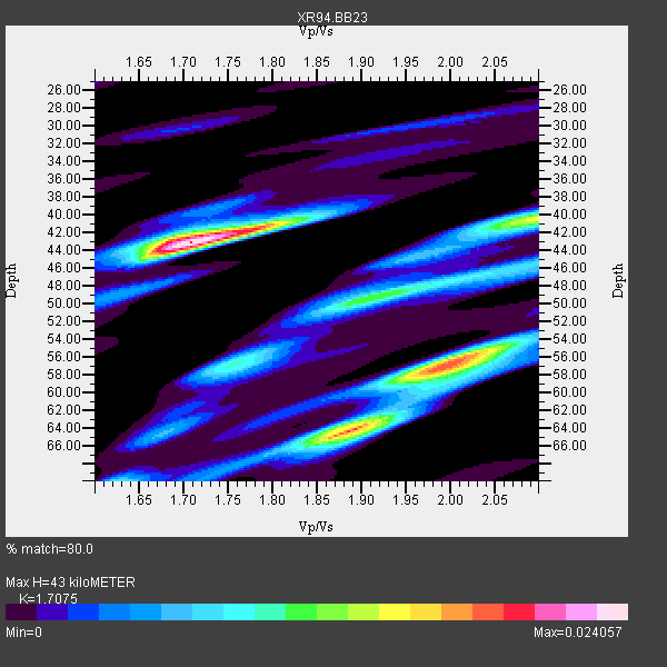
| Crust2 Type: | RD,orogen/70km Tibet, no seds. |
| Thickness Estimate: | 43 km |
| Thickness StdDev: | 8.1 km |
| Vp/Vs Estimate: | 1.71 |
| Vp/Vs StdDev: | 0.15 |
| Vs Estimate: | 3.815 km/s |
| Poisson's Ratio: | 0.24 |
| Peak Value: | 0.02 |
| Assumed Vp: | 6.514 km/s |
| Ps Weight: | 0.33333334 |
| PpPs Weight: | 0.33333334 |
| PsPs Weight: | 0.33333328 |
| Residual Complexity: | 0.807 |
| Nearby stations H: | +- |
| (2.0 deg) Vp/Vs: | +- |
1 with match > 90% ( 9.090909 %) and 11 with match > 80% ( 100.0 %) out of 11.
Download stack as xyz text file.
Azimuth Distribution of Events:

Prior Results for this Station
| Study | Thickness | Vp/Vs | Vp | Vs | Poissons Ratio | Extra |
| EARS | 43 km | 1.71 | 6.514 km/s | 3.815 km/s | 0.24 | |
| Crust2.0 | 70 km | 1.76 | 6.514 km/s | 3.706 km/s | 0.26 | RD,orogen/70km Tibet, no seds. |
| Global Maxima | 43 km | 1.71 | 6.514 km/s | 3.815 km/s | 0.24 | amp=0.024057 |
| Local Maxima 1 | 64 km | 1.88 | 6.514 km/s | 3.456 km/s | 0.30 | amp=0.01970231 |
| Local Maxima 2 | 57 km | 2.00 | 6.514 km/s | 3.265 km/s | 0.33 | amp=0.015506936 |
| Local Maxima 3 | 40 km | 2.10 | 6.514 km/s | 3.106 km/s | 0.35 | amp=0.01495845 |
| Local Maxima 4 | 57 km | 1.75 | 6.514 km/s | 3.717 km/s | 0.26 | amp=0.009463032 |
| Predicted Arrivals for vertical incidence (zero ray parameter) | |
| Ps | 4.67 SECOND |
| PpPs | 17.87 SECOND |
| PsPs/PpSs | 22.54 SECOND |
Events Processed for this Station
Download zip of receiver functions as SAC
Plot maxima for each earthquake.
Events Used in the Stack
(11 events)| Radial Match | Distance | Baz | FERegion | Time | Lat/Lon | Depth | Magnitude |
| 96.09101 | 48.1 deg | 55.442 deg | Kuril Islands | 1994/10/04 13:22:58 GMT | (43.7, 147.3) | 33 km | 7.4 MB, 8.1 MS, 8.3 UNKNOWN, 8.2 MW |
| 88.697075 | 32.4 deg | 279.782 deg | Southern Iran | 1994/06/20 09:09:04 GMT | (28.9, 52.6) | 17 km | 5.9 MB, 5.7 MS, 5.9 UNKNOWN, 5.8 MD |
| 88.670456 | 47.1 deg | 122.216 deg | Halmahera, Indonesia | 1994/10/08 21:44:09 GMT | (-1.2, 128.0) | 31 km | 6.3 MB, 6.8 MS, 6.8 UNKNOWN, 6.9 MW |
| 87.40546 | 50.1 deg | 54.02 deg | East Of Kuril Islands | 1994/08/28 18:37:19 GMT | (44.7, 150.2) | 14 km | 6.0 MB, 6.5 MS, 6.3 UNKNOWN, 6.7 MW |
| 87.21773 | 50.1 deg | 54.09 deg | East Of Kuril Islands | 1994/08/14 00:46:22 GMT | (44.7, 150.1) | 33 km | 5.9 MB, 5.8 MS, 5.4 UNKNOWN, 6.1 MW |
| 86.56757 | 50.1 deg | 54.065 deg | East Of Kuril Islands | 1994/08/18 04:42:59 GMT | (44.7, 150.2) | 33 km | 6.1 MB, 6.5 MS, 6.6 UNKNOWN, 6.5 MW |
| 84.33848 | 37.4 deg | 56.698 deg | Primor'ye, Russia | 1994/07/21 18:36:31 GMT | (42.3, 132.9) | 473 km | 6.4 MB, 7.2 UNKNOWN |
| 83.035324 | 44.7 deg | 63.795 deg | Off East Coast Of Honshu, Japan | 1994/08/16 10:09:34 GMT | (37.8, 142.5) | 34 km | 5.8 MB, 5.2 MS, 5.1 UNKNOWN, 5.8 MW |
| 80.46453 | 47.1 deg | 122.281 deg | Halmahera, Indonesia | 1994/10/13 05:04:28 GMT | (-1.2, 127.9) | 33 km | 6.0 MB, 6.4 MS, 6.5 UNKNOWN, 6.4 MW |
| 80.36757 | 35.5 deg | 107.05 deg | Luzon, Philippines | 1994/10/12 06:02:50 GMT | (13.7, 124.5) | 33 km | 5.4 MB, 5.7 MS, 5.6 UNKNOWN |
| 80.13852 | 41.0 deg | 116.202 deg | Mindanao, Philippines | 1994/07/06 09:13:11 GMT | (6.0, 125.9) | 164 km | 5.7 MB, 6.1 UNKNOWN |
Losers
(0 events)| Radial Match | Distance | Baz | FERegion | Time | Lat/Lon | Depth | Magnitude | Reason |
