You are here: Home > Network List > IC - New China Digital Seismograph Network Stations List
> Station HIA Hailar, Neimenggu Autonomous Region, China > Earthquake Result Viewer
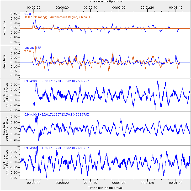
HIA Hailar, Neimenggu Autonomous Region, China - Earthquake Result Viewer
*The percent match for this event was below the threshold and hence no stack was calculated.
| Earthquake location: |
Off W Coast Of Northern Sumatra |
| Earthquake latitude/longitude: |
1.4/96.9 |
| Earthquake time(UTC): |
2017/11/20 (324) 23:41:56 GMT |
| Earthquake Depth: |
19 km |
| Earthquake Magnitude: |
5.2 Mww |
| Earthquake Catalog/Contributor: |
NEIC PDE/us |
|
| Network: |
IC New China Digital Seismograph Network |
| Station: |
HIA Hailar, Neimenggu Autonomous Region, China |
| Lat/Lon: |
49.27 N/119.74 E |
| Elevation: |
620 m |
|
| Distance: |
51.6 deg |
| Az: |
18.91 deg |
| Baz: |
209.645 deg |
| Ray Param: |
$rayparam |
*The percent match for this event was below the threshold and hence was not used in the summary stack. |
|
| Radial Match: |
71.42216 % |
| Radial Bump: |
327 |
| Transverse Match: |
57.885494 % |
| Transverse Bump: |
364 |
| SOD ConfigId: |
2429771 |
| Insert Time: |
2017-12-04 23:43:00.355 +0000 |
| GWidth: |
2.5 |
| Max Bumps: |
400 |
| Tol: |
0.001 |
|
Signal To Noise
| Channel | StoN | STA | LTA |
| IC:HIA:00:BHZ:20171120T23:50:30.268979Z | 3.0927498 | 2.6315507E-7 | 8.5087734E-8 |
| IC:HIA:00:BH1:20171120T23:50:30.268979Z | 2.0366087 | 1.4787008E-7 | 7.260603E-8 |
| IC:HIA:00:BH2:20171120T23:50:30.268979Z | 1.0756134 | 9.019935E-8 | 8.385852E-8 |
| Arrivals |
| Ps | |
| PpPs | |
| PsPs/PpSs | |


