FA02 fled station 2 - Earthquake Result Viewer
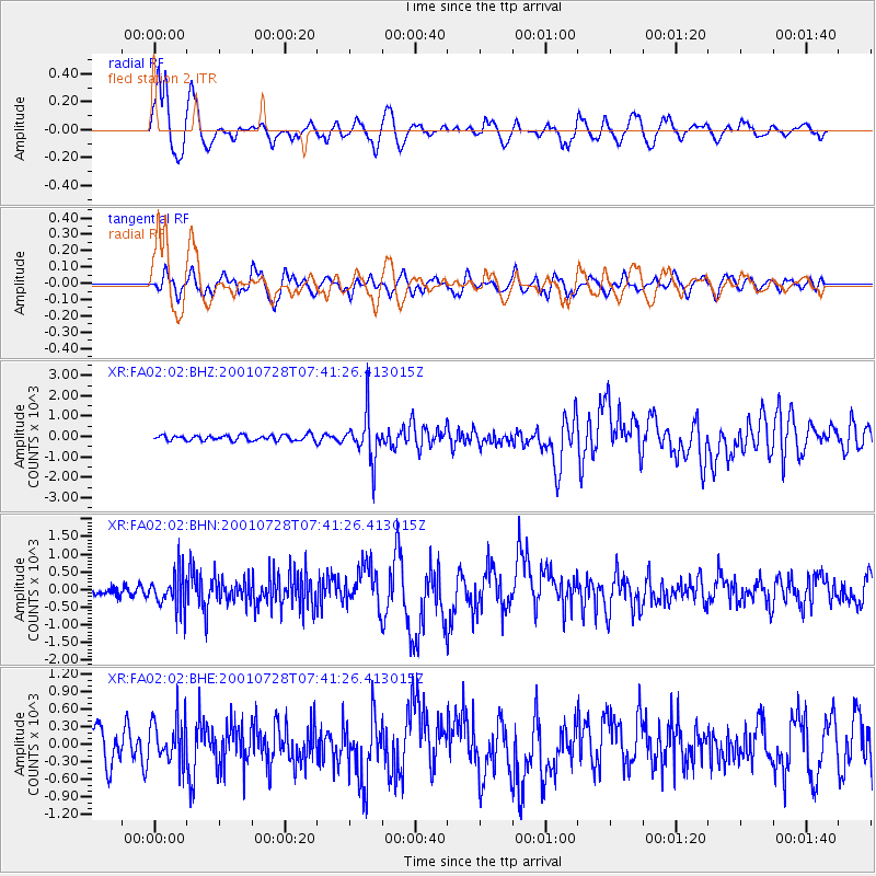
Earthquake location: Southern Alaska
Earthquake latitude/longitude: 59.0/-155.1
Earthquake time(UTC): 2001/07/28 (209) 07:32:43 GMT
Earthquake Depth: 131 km
Earthquake Magnitude: 5.7 MB, 5.7 MS, 6.6 MW, 6.2 ME
Earthquake Catalog/Contributor: WHDF/NEIC
Network: XR Florida to Edmonton Seismic Experiment
Station: FA02 fled station 2
Lat/Lon: 31.17 N/83.53 W
Elevation: 39 m
Distance: 54.5 deg
Az: 87.562 deg
Baz: 322.925 deg
Ray Param: 0.06499426
Estimated Moho Depth: 17.25 km
Estimated Crust Vp/Vs: 1.65
Assumed Crust Vp: 6.565 km/s
Estimated Crust Vs: 3.972 km/s
Estimated Crust Poisson's Ratio: 0.21
Radial Match: 86.33292 %
Radial Bump: 400
Transverse Match: 65.59975 %
Transverse Bump: 400
SOD ConfigId: 248956
Insert Time: 2010-03-09 08:08:30.582 +0000
GWidth: 2.5
Max Bumps: 400
Tol: 0.001

Signal To Noise

ChannelStoNSTALTA
XR:FA02:02:BHN:20010728T07:41:26.413015Z2.7893546497.89267178.49744
XR:FA02:02:BHE:20010728T07:41:26.413015Z1.2605109374.74094297.29288
XR:FA02:02:BHZ:20010728T07:41:26.413015Z8.4197451122.2897133.29259
Arrivals
Ps1.8 SECOND
PpPs6.6 SECOND
PsPs/PpSs8.4 SECOND