FA13 fled station 13 - Earthquake Result Viewer
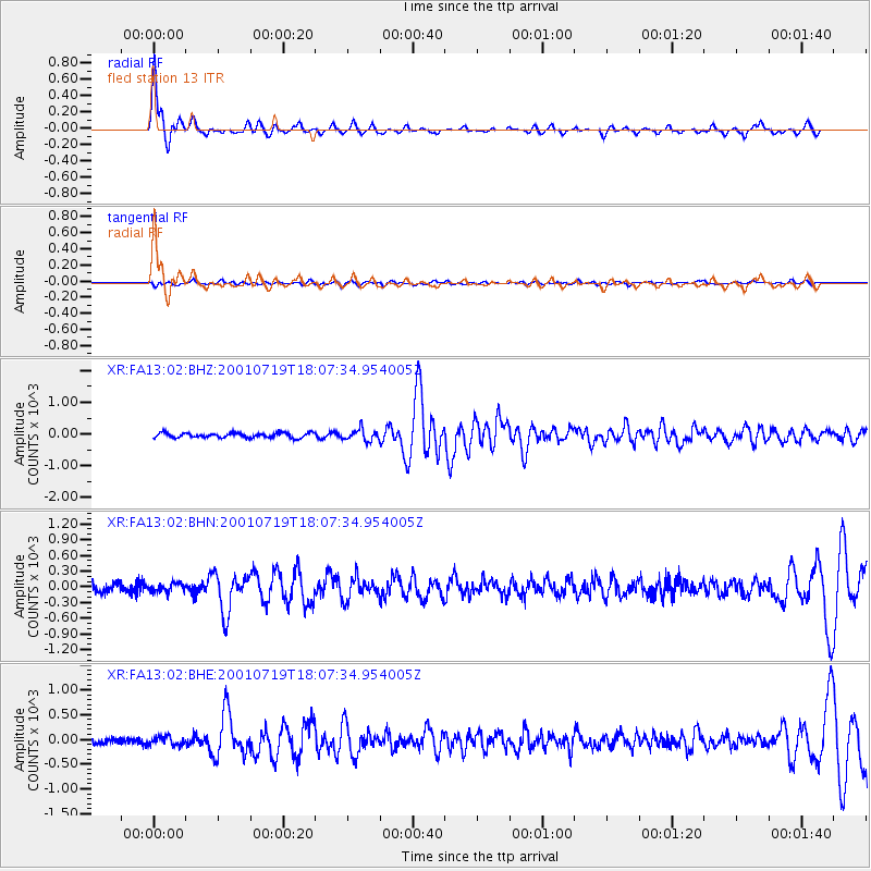
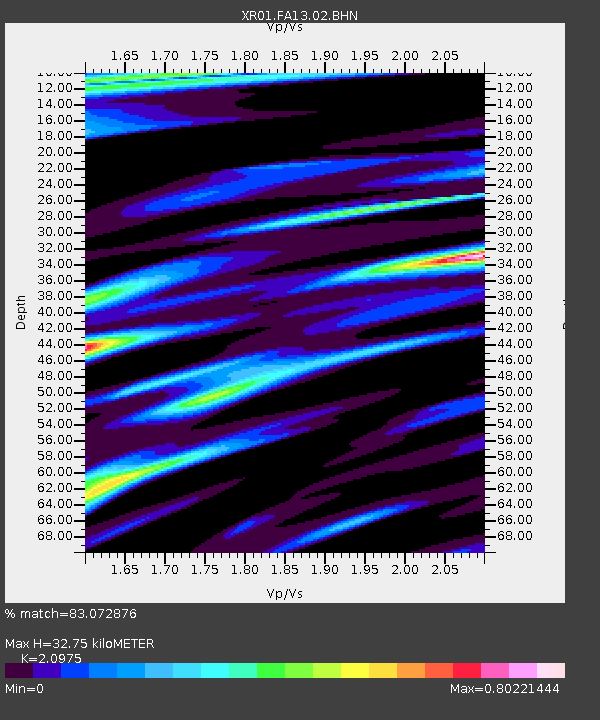
Earthquake location: Kodiak Island Region, Alaska
Earthquake latitude/longitude: 57.2/-151.0
Earthquake time(UTC): 2001/07/19 (200) 18:00:40 GMT
Earthquake Depth: 33 km
Earthquake Magnitude: 5.9 MB, 5.4 MS, 5.9 MW, 5.9 ML
Earthquake Catalog/Contributor: WHDF/NEIC
Network: XR Florida to Edmonton Seismic Experiment
Station: FA13 fled station 13
Lat/Lon: 41.31 N/94.01 W
Elevation: 252 m
Distance: 39.2 deg
Az: 88.732 deg
Baz: 313.757 deg
Ray Param: 0.07505371
Estimated Moho Depth: 32.75 km
Estimated Crust Vp/Vs: 2.10
Assumed Crust Vp: 6.498 km/s
Estimated Crust Vs: 3.098 km/s
Estimated Crust Poisson's Ratio: 0.35
Radial Match: 83.072876 %
Radial Bump: 289
Transverse Match: 54.85821 %
Transverse Bump: 400
SOD ConfigId: 248956
Insert Time: 2010-03-09 08:11:05.845 +0000
GWidth: 2.5
Max Bumps: 400
Tol: 0.001

Signal To Noise

ChannelStoNSTALTA
XR:FA13:02:BHN:20010719T18:07:34.954005Z1.007247479.5549478.98251
XR:FA13:02:BHE:20010719T18:07:34.954005Z1.164409886.4595874.251854
XR:FA13:02:BHZ:20010719T18:07:34.954005Z2.3947334179.8764875.113365
Arrivals
Ps5.9 SECOND
PpPs15 SECOND
PsPs/PpSs21 SECOND