
Station XR FA13 - fled station 13
Network: XR01 - Florida to Edmonton Seismic Experiment
Nearby stations (2 deg radius)
| Station | Name | (Lat, Lon) | Start / End | Elevation |
| FA13 | fled station 13 | (41.31, -94.01) | 2001-05-24 / 2002-12-31 | 0.3 km |
| Crust2 Type: | D9,Platform 1 km seds. |
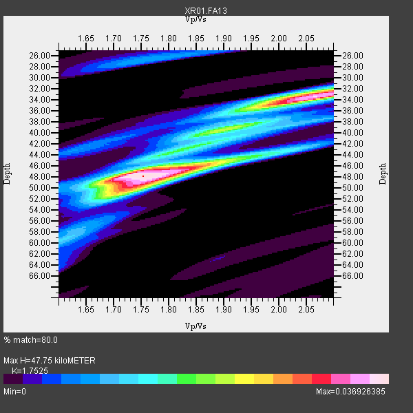
| Thickness Estimate: | 48 km |
| Thickness StdDev: | 6.7 km |
| Vp/Vs Estimate: | 1.75 |
| Vp/Vs StdDev: | 0.15 |
| Vs Estimate: | 3.708 km/s |
| Poisson's Ratio: | 0.26 |
| Peak Value: | 0.04 |
| Assumed Vp: | 6.498 km/s |
| Ps Weight: | 0.33333334 |
| PpPs Weight: | 0.33333334 |
| PsPs Weight: | 0.33333328 |
| Residual Complexity: | 0.673 |
| Nearby stations H: | +- |
| (2.0 deg) Vp/Vs: | +- |
12 with match > 90% ( 66.666664 %) and 18 with match > 80% ( 100.0 %) out of 18.
Download stack as xyz text file.
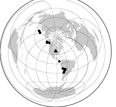
Azimuth Distribution of Events:
Prior Results for this Station
| Study | Thickness | Vp/Vs | Vp | Vs | Poissons Ratio | Extra |
| EARS | 48 km | 1.75 | 6.498 km/s | 3.708 km/s | 0.26 | |
| Crust2.0 | 41 km | 1.77 | 6.498 km/s | 3.666 km/s | 0.27 | D9,Platform 1 km seds. |
| Global Maxima | 48 km | 1.75 | 6.498 km/s | 3.708 km/s | 0.26 | amp=0.036926385 |
| Local Maxima 1 | 33 km | 2.07 | 6.498 km/s | 3.147 km/s | 0.35 | amp=0.03404726 |
| Local Maxima 2 | 49 km | 1.75 | 6.498 km/s | 3.718 km/s | 0.26 | amp=0.020434799 |
| Local Maxima 3 | 48 km | 1.73 | 6.498 km/s | 3.761 km/s | 0.25 | amp=0.016063923 |
| Local Maxima 4 | 39 km | 2.01 | 6.498 km/s | 3.229 km/s | 0.34 | amp=0.009757985 |
| Predicted Arrivals for vertical incidence (zero ray parameter) | |
| Ps | 5.53 SECOND |
| PpPs | 20.23 SECOND |
| PsPs/PpSs | 25.76 SECOND |
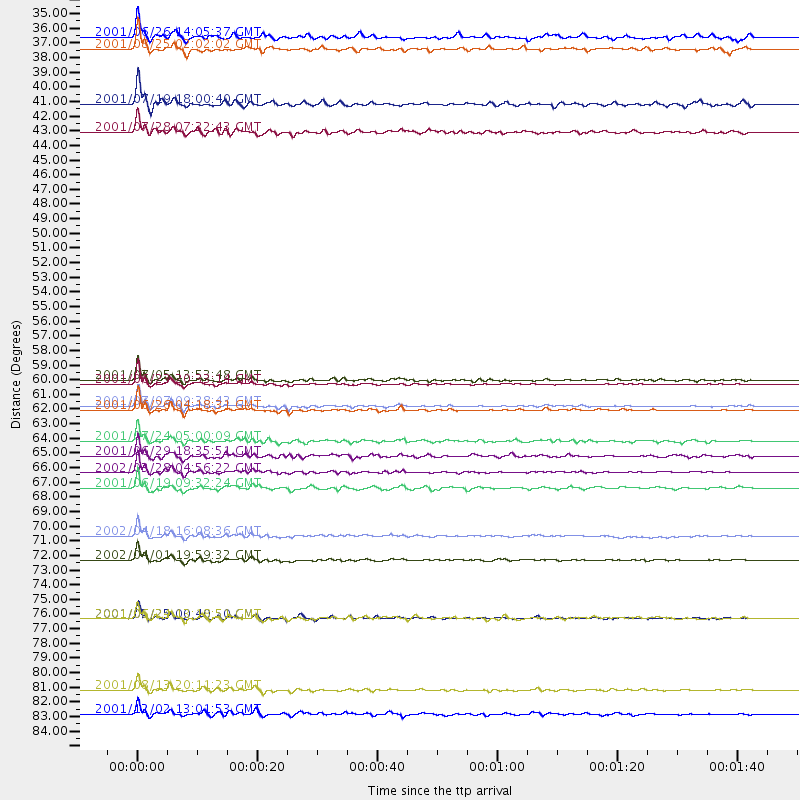
Events Processed for this Station
Download zip of receiver functions as SAC
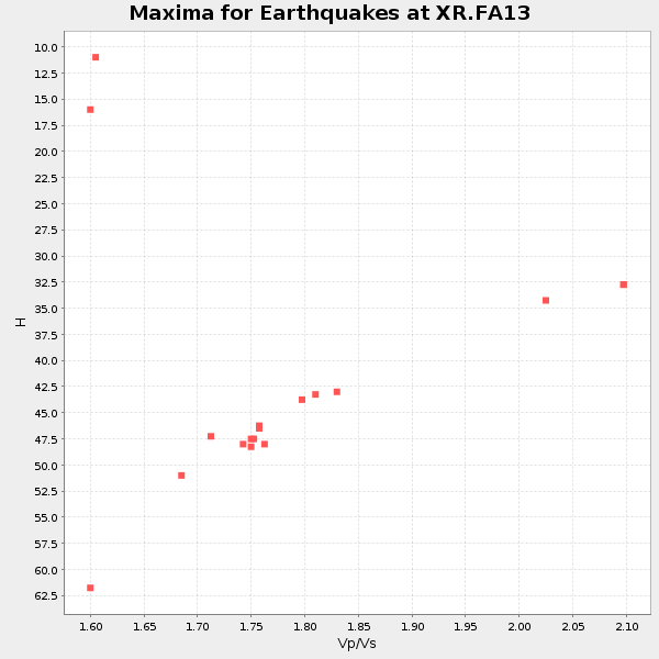
Plot maxima for each earthquake.
Events Used in the Stack
(18 events)| Radial Match | Distance | Baz | FERegion | Time | Lat/Lon | Depth | Magnitude |
| 98.74157 | 62.3 deg | 155.831 deg | Near Coast Of Peru | 2001/06/26 04:18:31 GMT | (-17.7, -71.6) | 24 km | 6.2 MB, 6.7 MS, 6.8 MW, 6.7 ME |
| 98.67002 | 60.3 deg | 157.37 deg | Near Coast Of Peru | 2001/06/23 20:33:14 GMT | (-16.3, -73.6) | 33 km | 6.7 MB, 8.2 MS, 8.4 MW, 7.8 ME |
| 98.48769 | 62.0 deg | 156.195 deg | Near Coast Of Peru | 2001/07/07 09:38:43 GMT | (-17.5, -72.1) | 33 km | 6.6 MB, 7.3 MS, 7.6 MW, 7.5 ME |
| 98.09977 | 67.0 deg | 154.037 deg | Chile-Bolivia Border Region | 2002/03/28 04:56:22 GMT | (-21.7, -68.3) | 125 km | 6.1 MB, 6.5 MW, 6.5 MW |
| 98.042435 | 60.0 deg | 157.674 deg | Near Coast Of Peru | 2001/07/05 13:53:48 GMT | (-16.1, -74.0) | 62 km | 6.2 MB, 6.6 MW, 6.5 ME |
| 96.53082 | 73.7 deg | 159.581 deg | Near Coast Of Central Chile | 2002/04/01 19:59:32 GMT | (-29.7, -71.4) | 71 km | 6.1 MB, 6.4 MW, 6.4 MW |
| 95.775505 | 78.1 deg | 319.403 deg | Kuril Islands | 2001/05/25 00:40:50 GMT | (44.3, 148.4) | 33 km | 6.1 MB, 6.7 MS, 6.7 MW, 6.6 MW |
| 95.24598 | 83.4 deg | 320.69 deg | Hokkaido, Japan Region | 2001/08/13 20:11:23 GMT | (41.0, 142.3) | 38 km | 6.0 MB, 6.3 MS, 6.4 MW, 6.3 ME |
| 93.95602 | 71.9 deg | 158.195 deg | Near Coast Of Northern Chile | 2002/04/18 16:08:36 GMT | (-27.5, -70.6) | 62 km | 6.2 MB, 6.7 MW, 6.6 MW |
| 93.678474 | 85.3 deg | 320.39 deg | Eastern Honshu, Japan | 2001/12/02 13:01:53 GMT | (39.4, 141.1) | 124 km | 6.1 MB, 6.5 MW, 6.5 MW |
| 92.523964 | 64.7 deg | 154.078 deg | Northern Chile | 2001/07/24 05:00:09 GMT | (-19.4, -69.3) | 33 km | 5.7 MB, 6.2 MS, 6.3 MW, 6.3 MW |
| 91.8195 | 35.0 deg | 160.31 deg | South Of Panama | 2001/08/25 02:02:02 GMT | (7.6, -82.8) | 24 km | 5.9 MB, 5.7 MS, 6.2 MW, 6.1 MW |
| 87.53441 | 68.2 deg | 154.026 deg | Chile-Bolivia Border Region | 2001/06/19 09:32:24 GMT | (-22.7, -67.9) | 147 km | 5.5 MB, 5.2 MS, 6.1 MW, 5.9 MW |
| 84.53445 | 65.8 deg | 151.207 deg | Southern Bolivia | 2001/06/29 18:35:51 GMT | (-19.5, -66.3) | 274 km | 5.7 MB, 6.1 MW, 6.1 MW |
| 83.78914 | 78.1 deg | 319.285 deg | Kuril Islands | 2001/06/24 13:18:51 GMT | (44.2, 148.5) | 33 km | 5.8 MB, 5.7 MS, 6.0 MW |
| 83.072876 | 39.2 deg | 313.757 deg | Kodiak Island Region, Alaska | 2001/07/19 18:00:40 GMT | (57.2, -151.0) | 33 km | 5.9 MB, 5.4 MS, 5.9 MW, 5.9 ML |
| 81.817795 | 34.1 deg | 321.727 deg | Southern Yukon Territory, Canada | 2001/06/26 14:05:37 GMT | (61.3, -140.1) | 10 km | 5.8 MB, 5.4 MS, 6.0 ML, 5.8 MW |
| 81.388054 | 41.3 deg | 316.691 deg | Southern Alaska | 2001/07/28 07:32:43 GMT | (59.0, -155.1) | 131 km | 5.7 MB, 5.7 MS, 6.6 MW, 6.2 ME |
Losers
(0 events)| Radial Match | Distance | Baz | FERegion | Time | Lat/Lon | Depth | Magnitude | Reason |
