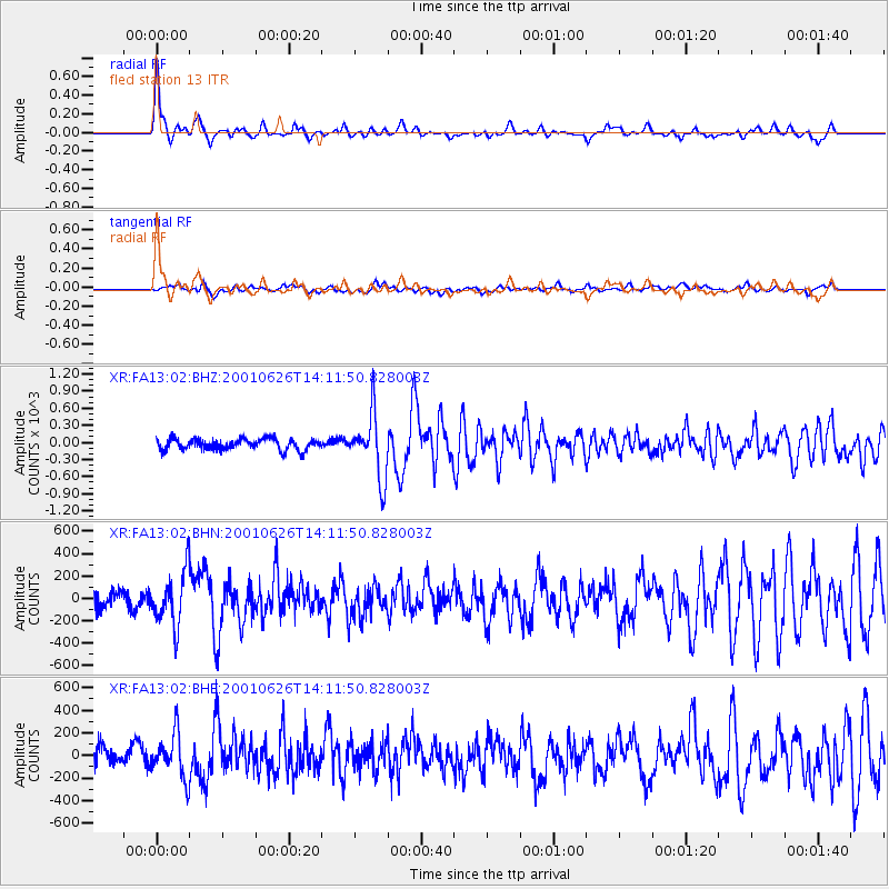
FA13 fled station 13 - Earthquake Result Viewer
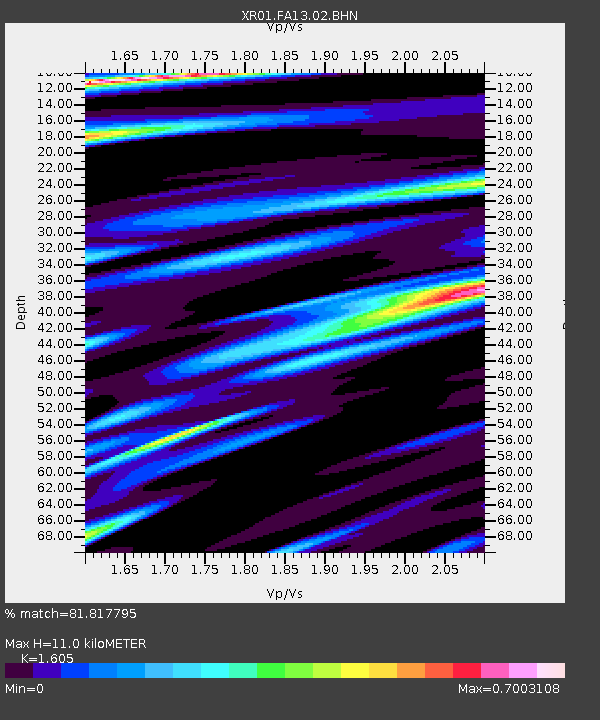
Earthquake location: Southern Yukon Territory, Canada
Earthquake latitude/longitude: 61.3/-140.1
Earthquake time(UTC): 2001/06/26 (177) 14:05:37 GMT
Earthquake Depth: 10 km
Earthquake Magnitude: 5.8 MB, 5.4 MS, 6.0 ML, 5.8 MW
Earthquake Catalog/Contributor: WHDF/NEIC
Network: XR Florida to Edmonton Seismic Experiment
Station: FA13 fled station 13
Lat/Lon: 41.31 N/94.01 W
Elevation: 252 m
Distance: 34.1 deg
Az: 104.56 deg
Baz: 321.727 deg
Ray Param: 0.07790854
Estimated Moho Depth: 11.0 km
Estimated Crust Vp/Vs: 1.61
Assumed Crust Vp: 6.498 km/s
Estimated Crust Vs: 4.048 km/s
Estimated Crust Poisson's Ratio: 0.18
Radial Match: 81.817795 %
Radial Bump: 345
Transverse Match: 53.6373 %
Transverse Bump: 400
SOD ConfigId: 248956
Insert Time: 2010-03-09 08:11:11.609 +0000
GWidth: 2.5
Max Bumps: 400
Tol: 0.001

Signal To Noise

ChannelStoNSTALTA
XR:FA13:02:BHN:20010626T14:11:50.828003Z2.1398668240.79768112.52928
XR:FA13:02:BHE:20010626T14:11:50.828003Z1.5134218192.55086127.22882
XR:FA13:02:BHZ:20010626T14:11:50.828003Z5.6474233547.061696.86923
Arrivals
Ps1.1 SECOND
PpPs4.0 SECOND
PsPs/PpSs5.2 SECOND